IMAGES TAKEN NEAR TO
Alexander Drive, HUNTLY, AB54 8NZ
Introduction
This page details the photographs taken nearby to Alexander Drive, AB54 8NZ by members of the Geograph project.
The Geograph project started in 2005 with the aim of publishing, organising and preserving representative images for every square kilometre of Great Britain, Ireland and the Isle of Man.

There are currently over 7.5m images from over14,400 individuals and you can help contribute to the project by visiting https://www.geograph.org.uk
Image Map
Images are licensed for reuse under creativecommons.org/licenses/by-sa/2.0
Notes
- Clicking on the map will re-center to the selected point.
- The higher the marker number, the further away the image location is from the centre of the postcode.
Image Listing (42 Images Found)
Images are licensed for reuse under creativecommons.org/licenses/by-sa/2.0
Image
Details
Distance
1
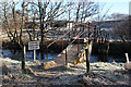
Unsafe Bridge
This notice raises one or two questions. Why is the bridge unsafe? It looks pretty solid on cursory inspection. And if it is unsafe, is it sufficient just to put up a notice rather than barricading it completely. It carries a path across the River Bogie between Huntly and Pirriesmill.
Image: © Anne Burgess
Taken: 11 Feb 2015
0.09 miles
2
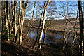
River Bogie
A quiet reach of the river, seen through the trees lining the bank.
Image: © Anne Burgess
Taken: 11 Feb 2015
0.11 miles
3
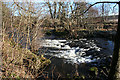
Weir on the River Bogie
The 1:25,000 map marks the weir next to the Laird's Intake, and the first edition of the six-inch map shows that the lade (See Image]) from the weir supplied the Old Distillery a little distance downstream.
Image: © Anne Burgess
Taken: 11 Feb 2015
0.15 miles
4
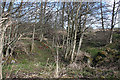
Mill Lade
The mid-Victorian and late Victorian ei x-inch maps both show a mill lade (or mill lead) from the Image] at the Laird's Intake to the site of the old distillery. This must be the start of the lade, though it is partially blocked by what looks like masonry, which is what I am standing on. However none of the maps shows any building on this site.
Image: © Anne Burgess
Taken: 10 Mar 2015
0.15 miles
5
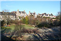
Houses above the River Bogie
These houses in Lennox Terrace face east, away from the street and towards the river, which is just out of sight at lower right.
Image: © Anne Burgess
Taken: 11 Feb 2015
0.15 miles
6
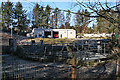
Waste Water Treatment Plant
This is Huntly's sewage works, inconspicuously sited next to the River Bogie, into which the treated water is presumably discharged.
Image: © Anne Burgess
Taken: 11 Feb 2015
0.16 miles
7
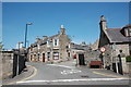
Junction of Bogie Street with Old Road and Mill Road, Huntly
Image: © Bill Harrison
Taken: 29 May 2016
0.16 miles
8
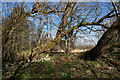
Path by the Bogie Water
Though there is a track just to the right, there is an informal path close to the river, wending its way round and even over fallen and apparently falling trees. The white flowers are Image
Image: © Anne Burgess
Taken: 10 Mar 2015
0.16 miles
9
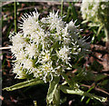
White Butterbur (Petasites albus)
An alien introduced to and becoming increasingly established in damp shady places in north-east Scotland.
Image: © Anne Burgess
Taken: 10 Mar 2015
0.16 miles
10
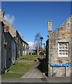
Jake Forbes Close
Apart from the satellite dishes, street lamps and garish blue street signs, this could be a glimpse into the 18th century in the oldest part of Huntly, on the west bank of the River Bogie.
Jake Forbes was a traditional musician who became a popular local celebrity.
Image: © Anne Burgess
Taken: 10 Mar 2015
0.17 miles