IMAGES TAKEN NEAR TO
Old Road, HUNTLY, AB54 8JH
Introduction
This page details the photographs taken nearby to Old Road, AB54 8JH by members of the Geograph project.
The Geograph project started in 2005 with the aim of publishing, organising and preserving representative images for every square kilometre of Great Britain, Ireland and the Isle of Man.

There are currently over 7.5m images from over14,400 individuals and you can help contribute to the project by visiting https://www.geograph.org.uk
Image Map
Images are licensed for reuse under creativecommons.org/licenses/by-sa/2.0
Notes
- Clicking on the map will re-center to the selected point.
- The higher the marker number, the further away the image location is from the centre of the postcode.
Image Listing (101 Images Found)
Images are licensed for reuse under creativecommons.org/licenses/by-sa/2.0
Image
Details
Distance
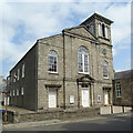
3
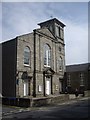
Strathbogie Parish Church, Huntly
The former 'non-intrusion' Huntly kirk from 1840-41, when most of the Established congregation at Huntly 'came out' in sympathy with the congregation at Marnoch, some 10 km to the north-east in a row over patronage (see Thomas Brown: Annals of the Disruption, 1892 edition, p. 22, available from archive.org), and an important event leading to the 1843 Disruption (https://en.wikipedia.org/wiki/Disruption_of_1843 ; the Huntly congregation joined the free kirk at that point. The Italianate front dates from 1862. B listed (LB34955): http://portal.historicenvironment.scot/designation/LB34955 . Next door is the 'prayer hall'.
Image: © Bill Harrison
Taken: 29 May 2016
0.07 miles
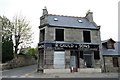
4
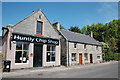
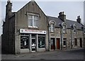
Gauld's grocers
Now closed: the 'fruiterer' branding is positively archaic.
Image: © Bill Harrison
Taken: 29 May 2016
0.07 miles
5
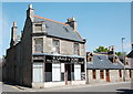
R Gauld & Son
R Gauld & Son, Bogie Street. Huntly.
Image: © Mary Rodgers
Taken: 13 May 2017
0.07 miles
6
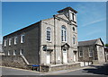
Strathbogie Parish Kirk
The kirk was built in 1840-1841, and became part of the Free Kirk at the Disruption in 1843. The Italianate tower was added in 1862, to a design by James Matthews.
Image: © Anne Burgess
Taken: 19 Jul 2021
0.08 miles
7
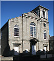
Strathbogie Parish Kirk
The kirk was built in 1840-1841, and became part of the Free Kirk at the Disruption in 1843. The Italianate tower was added in 1862, to a design by James Matthews.
Image: © Anne Burgess
Taken: 10 Mar 2015
0.08 miles
8
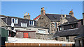
Roofs and Lines
A picturesque muddle of backs of houses on Old Road (I think!) seen from Duke Street.
Image: © Anne Burgess
Taken: 10 Mar 2015
0.09 miles
9
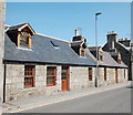
Single-storey cottages, Bogie Street, Huntly
Image: © Bill Harrison
Taken: 29 May 2016
0.10 miles
10
A Charity Shop in Duke Street, Huntly
Image: © Stanley Howe
Taken: 24 Apr 2010
0.10 miles