IMAGES TAKEN NEAR TO
Kinnoir, HUNTLY, AB54 7YT
Introduction
This page details the photographs taken nearby to AB54 7YT by members of the Geograph project.
The Geograph project started in 2005 with the aim of publishing, organising and preserving representative images for every square kilometre of Great Britain, Ireland and the Isle of Man.

There are currently over 7.5m images from over14,400 individuals and you can help contribute to the project by visiting https://www.geograph.org.uk
Image Map
Images are licensed for reuse under creativecommons.org/licenses/by-sa/2.0
Notes
- Clicking on the map will re-center to the selected point.
- The higher the marker number, the further away the image location is from the centre of the postcode.
Image Listing (3 Images Found)
Images are licensed for reuse under creativecommons.org/licenses/by-sa/2.0
Image
Details
Distance
1
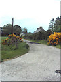
Track to Bogenspro
Track to Bogenspro farm, one of the farm buildings can be seen in the centre of the picture. The cottage to the right of centre is one of the farm cottages for Bogenspro, the farmhouse itself can just be seen through the trees to the left.
Image: © Andrew Stuart
Taken: 26 May 2007
0.04 miles
2
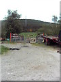
Livestock Loading Area
This area is used for holding livestock prior to loading onto cattle lorry for transporting.
Image: © Andrew Stuart
Taken: 26 May 2007
0.14 miles
3
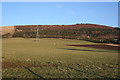
Near Bogenspro
All the views towards Fourman Hill from the south-west tend to be dominated by the electricity pylons that march across the landscape. This one is north-east of Bogenspro.
Image: © Anne Burgess
Taken: 11 Feb 2015
0.21 miles