IMAGES TAKEN NEAR TO
HUNTLY, AB54 7UY
Introduction
This page details the photographs taken nearby to AB54 7UY by members of the Geograph project.
The Geograph project started in 2005 with the aim of publishing, organising and preserving representative images for every square kilometre of Great Britain, Ireland and the Isle of Man.

There are currently over 7.5m images from over14,400 individuals and you can help contribute to the project by visiting https://www.geograph.org.uk
Image Map
Images are licensed for reuse under creativecommons.org/licenses/by-sa/2.0
Notes
- Clicking on the map will re-center to the selected point.
- The higher the marker number, the further away the image location is from the centre of the postcode.
Image Listing (2 Images Found)
Images are licensed for reuse under creativecommons.org/licenses/by-sa/2.0
Image
Details
Distance
1
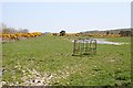
Newton of Auchingoul
This must be very slow-draining land, because it is still wet after several dry days in spite of being at the top of the hill.
Image: © Anne Burgess
Taken: 9 May 2008
0.12 miles
2
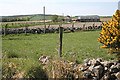
Newton of Haddo
The farm at the end of the road. It is a fine situation on a day like this, but it would be a different matter during a winter blizzard, being very exposed on the top of the hill.
Image: © Anne Burgess
Taken: 9 May 2008
0.15 miles