IMAGES TAKEN NEAR TO
South Street, HUNTLY, AB54 7TS
Introduction
This page details the photographs taken nearby to South Street, AB54 7TS by members of the Geograph project.
The Geograph project started in 2005 with the aim of publishing, organising and preserving representative images for every square kilometre of Great Britain, Ireland and the Isle of Man.

There are currently over 7.5m images from over14,400 individuals and you can help contribute to the project by visiting https://www.geograph.org.uk
Image Map
Images are licensed for reuse under creativecommons.org/licenses/by-sa/2.0
Notes
- Clicking on the map will re-center to the selected point.
- The higher the marker number, the further away the image location is from the centre of the postcode.
Image Listing (36 Images Found)
Images are licensed for reuse under creativecommons.org/licenses/by-sa/2.0
Image
Details
Distance
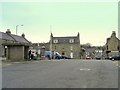
3
Main Street
Looking east down the hill from the Square towards Gallow Hill in the distance.
Image: © Anne Burgess
Taken: 27 Feb 2008
0.07 miles
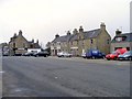
4
Main Street, Aberchirder (view from the Square)
Image: © Bill Harrison
Taken: 1 Jul 2017
0.07 miles
5
Aberchirder Library, Main Street, Aberchirder
A modest building serving an important purpose...
Image: © Bill Harrison
Taken: 1 Jul 2017
0.07 miles
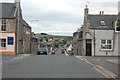
7
Villa, Main Street, Aberchirder
Located next door to the former mission hall, and possibly providing accommodation for the minister? The tiny annex to the left-hand side of the house has 'Police Station' carved into the stonework.
Image: © Bill Harrison
Taken: 1 Jul 2017
0.08 miles
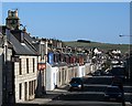
8
A Lane in Foggie
Foggie, short for Foggieloan, is how most local people refer to the village of Aberchirder (pronounce it Ab-er-HIR-der) because the village was laid out on the land of a farm called Foggieloan.
Image: © Anne Burgess
Taken: 27 Feb 2008
0.09 miles
9
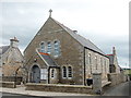
Marnoch Church Hall, Main Street, Aberchirder
Built ca. 1899 as a mission hall for the established church.
Image: © Bill Harrison
Taken: 1 Jul 2017
0.09 miles
10
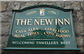
Sign of the New Inn, Aberchirder
Included mainly for the Aberchirder and Marnoch Community Council coat of arms: tierced in pairle reversed: 1st or two croziers in saltire azure; 2nd azure a boar's head couped or; 3rd argent a cross pattee azure. Above, a coronet of thistle leaves and pine cones. The arms were granted by Lord Lyon as recently as 1998 and are a splendid example of local civic heraldry.
Image: © Bill Harrison
Taken: 1 Jul 2017
0.09 miles