IMAGES TAKEN NEAR TO
Marnoch, HUNTLY, AB54 7NP
Introduction
This page details the photographs taken nearby to AB54 7NP by members of the Geograph project.
The Geograph project started in 2005 with the aim of publishing, organising and preserving representative images for every square kilometre of Great Britain, Ireland and the Isle of Man.

There are currently over 7.5m images from over14,400 individuals and you can help contribute to the project by visiting https://www.geograph.org.uk
Image Map
Images are licensed for reuse under creativecommons.org/licenses/by-sa/2.0
Notes
- Clicking on the map will re-center to the selected point.
- The higher the marker number, the further away the image location is from the centre of the postcode.
Image Listing (9 Images Found)
Images are licensed for reuse under creativecommons.org/licenses/by-sa/2.0
Image
Details
Distance
1
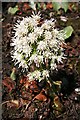
White Butterbur (Petasites albus)
This species of Butterbur is apparently commonest in eastern Scotland.
Image: © Anne Burgess
Taken: 27 Feb 2008
0.04 miles
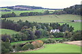
2
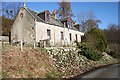
Dens of Mayen
This house has one of the best views I know Image], looking out over the River Deveron. The bank below it is thick with Butterbur.
Image: © Anne Burgess
Taken: 27 Feb 2008
0.04 miles
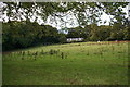
4
Denspark and Dens of Mayen
The white house on the right is Dens of Mayen, and the farm on the left is Denspark. The River Deveron is hidden here by the lie of the land.
Image: © Anne Burgess
Taken: 18 Jun 2014
0.13 miles
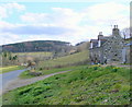
6
The House of Glennie amid varied autumnal shades.
Image: © Des Colhoun
Taken: 8 Oct 2006
0.17 miles
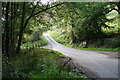
7
Near Turtory
Harvested fields slope down from the road near Turtory to the River Deveron. The house among the trees is Sunnyside, which is just in the next square.
Image: © Anne Burgess
Taken: 8 Oct 2008
0.18 miles
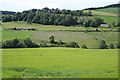
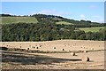
9
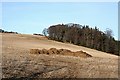
Field on Catstone Hill
A stubble field awaiting fertilisation, ploughing and sowing. Catstone Hill rises to the left.
Image: © Anne Burgess
Taken: 15 Feb 2008
0.23 miles