IMAGES TAKEN NEAR TO
Drumblade, HUNTLY, AB54 6YP
Introduction
This page details the photographs taken nearby to AB54 6YP by members of the Geograph project.
The Geograph project started in 2005 with the aim of publishing, organising and preserving representative images for every square kilometre of Great Britain, Ireland and the Isle of Man.

There are currently over 7.5m images from over14,400 individuals and you can help contribute to the project by visiting https://www.geograph.org.uk
Image Map
Images are licensed for reuse under creativecommons.org/licenses/by-sa/2.0
Notes
- Clicking on the map will re-center to the selected point.
- The higher the marker number, the further away the image location is from the centre of the postcode.
Image Listing (5 Images Found)
Images are licensed for reuse under creativecommons.org/licenses/by-sa/2.0
Image
Details
Distance
1
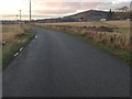
East Cruichie or Cruchie?
The maps call it Cruchie, and the farm sign says Cruichie. In all probability the name is Gaelic in origin, in which case the additional 'i' is appropriate.
Image: © Anne Burgess
Taken: 11 Feb 2015
0.08 miles
2
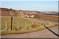
East Cruichie
The access road to and, in the distance, the farm of East Cruichie. The O.S. map gives the name as Easter Cruchie but the sign is different!
Image: © Andrew Wood
Taken: 28 Jul 2011
0.13 miles
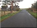
3
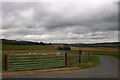
East Lodge Cottages
The cottages are marked as East Lodge on the map, at what would at one time have been the east entrance to Lessendrum House. Fourman Hill in the background.
Image: © Anne Burgess
Taken: 11 Feb 2015
0.15 miles
4
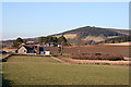
Newly renovated house at the roadside near Cruchie
Image: © Steven Brown
Taken: 10 Nov 2013
0.16 miles