IMAGES TAKEN NEAR TO
Drumblade, HUNTLY, AB54 6XP
Introduction
This page details the photographs taken nearby to AB54 6XP by members of the Geograph project.
The Geograph project started in 2005 with the aim of publishing, organising and preserving representative images for every square kilometre of Great Britain, Ireland and the Isle of Man.

There are currently over 7.5m images from over14,400 individuals and you can help contribute to the project by visiting https://www.geograph.org.uk
Image Map
Images are licensed for reuse under creativecommons.org/licenses/by-sa/2.0
Notes
- Clicking on the map will re-center to the selected point.
- The higher the marker number, the further away the image location is from the centre of the postcode.
Image Listing (3 Images Found)
Images are licensed for reuse under creativecommons.org/licenses/by-sa/2.0
Image
Details
Distance
1
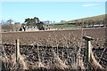
Cottages at Gerrieswells
The grid line more or less passes through between the two blocks of cottages at Gerrieswells, also spelled Garrieswells.
Image: © Anne Burgess
Taken: 11 Feb 2015
0.02 miles
2
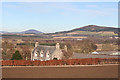
Gerrieswells
If you believe the 1:50,000 map, it's Gerrieswells. If you believe the 1:25,000 map it's Garrieswells. Take your pick. It's a largish farm with a good solid traditional farm house and a splendid view to Fourman Hill on the right and Knock Hill, further away, on the left.
Image: © Anne Burgess
Taken: 11 Feb 2015
0.15 miles
3
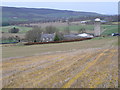
Gerrieswells Farm
Farm beside Newtongarry Hill.
Image: © James Allan
Taken: 30 Nov 2006
0.16 miles