IMAGES TAKEN NEAR TO
Glass, HUNTLY, AB54 4YE
Introduction
This page details the photographs taken nearby to AB54 4YE by members of the Geograph project.
The Geograph project started in 2005 with the aim of publishing, organising and preserving representative images for every square kilometre of Great Britain, Ireland and the Isle of Man.

There are currently over 7.5m images from over14,400 individuals and you can help contribute to the project by visiting https://www.geograph.org.uk
Image Map
Images are licensed for reuse under creativecommons.org/licenses/by-sa/2.0
Notes
- Clicking on the map will re-center to the selected point.
- The higher the marker number, the further away the image location is from the centre of the postcode.
Image Listing (7 Images Found)
Images are licensed for reuse under creativecommons.org/licenses/by-sa/2.0
Image
Details
Distance
1
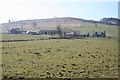
Lowrie and Hill of Dumeath
Morning haze over Lowrie, which stands on the lower slopes of the Hill of Dumeath.
Image: © Anne Burgess
Taken: 3 Apr 2009
0.03 miles
2
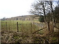
Lowrie Fields
Grassy fields and woods beside Lowrie.
Image: © Andrew Wood
Taken: 23 Jul 2010
0.11 miles
3
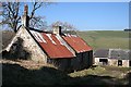
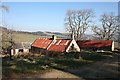
Townhead
At some time the old house at Townhead has been re-roofed with corrugated iron. The farm stands right by the road up the south slope of Glen Beg.
Image: © Anne Burgess
Taken: 3 Apr 2009
0.19 miles
4
Townhead
The buildings at Townhead, beside the south Glen Beg road.
Image: © Anne Burgess
Taken: 3 Apr 2009
0.20 miles
5
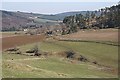
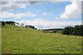
Townhead from Glenbeg
In the foreground are incised meanders carved in the glacial till by the Burn of Edinglassie. Townhead is at the bottom of the trees, and Lowrie is further down to the left.
Image: © Anne Burgess
Taken: 3 Apr 2009
0.20 miles
6
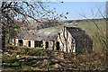
Steading at Townhead
Townhead is abandoned, but it looks as if the steading is still in use. Bonfail, on the far side of the glen, is visible in the distance.
Image: © Anne Burgess
Taken: 3 Apr 2009
0.20 miles