IMAGES TAKEN NEAR TO
HUNTLY, AB54 4US
Introduction
This page details the photographs taken nearby to AB54 4US by members of the Geograph project.
The Geograph project started in 2005 with the aim of publishing, organising and preserving representative images for every square kilometre of Great Britain, Ireland and the Isle of Man.

There are currently over 7.5m images from over14,400 individuals and you can help contribute to the project by visiting https://www.geograph.org.uk
Image Map
Images are licensed for reuse under creativecommons.org/licenses/by-sa/2.0
Notes
- Clicking on the map will re-center to the selected point.
- The higher the marker number, the further away the image location is from the centre of the postcode.
Image Listing (4 Images Found)
Images are licensed for reuse under creativecommons.org/licenses/by-sa/2.0
Image
Details
Distance
1
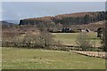
Dowmin by the Deveron
The River Deveron flows along the far side of the foreground field, and Dowmin is at the foot of Dunbennan Hill beyond.
Image: © Anne Burgess
Taken: 28 Mar 2009
0.02 miles
2
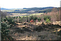
River Deveron
A gap in the trees just off the yellow route offers a view of a meander in the River Deveron.
Image: © Anne Burgess
Taken: 10 Feb 2015
0.15 miles
3
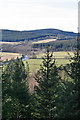
Deveron View
When the foreground spruce trees have grown a little taller, this view of the River Deveron will be obscured.
Image: © Anne Burgess
Taken: 10 Feb 2015
0.16 miles
4
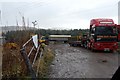
Vehicle yard by the River Deveron
Next to a long, low and derelict building, that appears to have been a poultry shed, is this assortment of vehicles. An odd sight in such a rural setting.
Image: © John Allan
Taken: 5 Feb 2007
0.24 miles