IMAGES TAKEN NEAR TO
Rhynie, HUNTLY, AB54 4NB
Introduction
This page details the photographs taken nearby to AB54 4NB by members of the Geograph project.
The Geograph project started in 2005 with the aim of publishing, organising and preserving representative images for every square kilometre of Great Britain, Ireland and the Isle of Man.

There are currently over 7.5m images from over14,400 individuals and you can help contribute to the project by visiting https://www.geograph.org.uk
Image Map
Images are licensed for reuse under creativecommons.org/licenses/by-sa/2.0
Notes
- Clicking on the map will re-center to the selected point.
- The higher the marker number, the further away the image location is from the centre of the postcode.
Image Listing (7 Images Found)
Images are licensed for reuse under creativecommons.org/licenses/by-sa/2.0
Image
Details
Distance
1
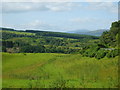
Across the Bogie Water
This is the view from beside the Image The Water of Bogie runs through the floor of the valley. Beyond it, the nearest farm is Barflat, which is just in the next square. Above and to the left is Bankhead (not to be confused with other places of the same name; this one is in the parish of Rhynie). The intervening farm, Sandholes, is hidden by the lie of the land.
Image: © Anne Burgess
Taken: 22 Oct 2015
0.10 miles
2
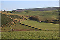
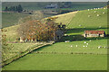
Bareflat Croft
In the foreground, seen from near the Craw Stane. Barflat and Bankhead farms in Image are also seen beyond the croft.
Image: © Stanley Howe
Taken: 5 Oct 2009
0.15 miles
3
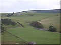
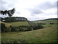
Drum Wood
Seen across the Water of Bogie, from near the Craw Stane.
Image: © Stanley Howe
Taken: 5 Oct 2009
0.19 miles
4
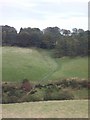
Sandholes Farm
From the look of the approach road, I think Sandholes may be one of the many farms that have been abandoned.
Image: © Anne Burgess
Taken: 5 Nov 2020
0.19 miles
5

Sandholes Croft
A long range shot of Sandholes Croft which looks rather neglected, it lies between Barflat and Bankhead above the Water of Bogie.
Image: © Andrew Wood
Taken: 7 Aug 2019
0.19 miles
6
The southern end of Drum Wood
Seen from near Rhynie cemetery. The wind turbine on right hand skyline is on Cairn More Image
Image: © Stanley Howe
Taken: 28 Aug 2013
0.21 miles