IMAGES TAKEN NEAR TO
Rhynie, HUNTLY, AB54 4NA
Introduction
This page details the photographs taken nearby to AB54 4NA by members of the Geograph project.
The Geograph project started in 2005 with the aim of publishing, organising and preserving representative images for every square kilometre of Great Britain, Ireland and the Isle of Man.

There are currently over 7.5m images from over14,400 individuals and you can help contribute to the project by visiting https://www.geograph.org.uk
Image Map
Images are licensed for reuse under creativecommons.org/licenses/by-sa/2.0
Notes
- Clicking on the map will re-center to the selected point.
- The higher the marker number, the further away the image location is from the centre of the postcode.
Image Listing (10 Images Found)
Images are licensed for reuse under creativecommons.org/licenses/by-sa/2.0
Image
Details
Distance
1
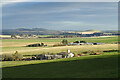
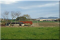
Stonedike and Cushnie
Two farms on the lower ground at the foot of Clova Hill. Stonedyke is just in this grid square but Cushnie is in the next one. The low hill towards the right is the Hill of Newleslie, and on the left is Bennachie.
Image: © Anne Burgess
Taken: 5 Nov 2020
0.02 miles
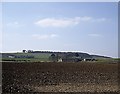
2
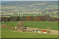
Stonedike Farm
The farm lies to the north of the Correen Hills, which are seen in the background. It is situated on the boundary between this kilometre square and that to the north but this side of the farm is in this square!
Image: © Morley Sewell
Taken: 27 Jan 2009
0.02 miles
3
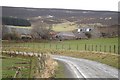
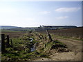
The Road To Meadowbank
This track goes down to Meadowbank farm not Meadowbank stadium, that's in Edinburgh.
Image: © Andrew Stuart
Taken: 31 May 2007
0.16 miles
4
A Robin in the Garden
I never thought I'd see a Reliant Robin as a garden ornament ! But here it is at Cairndard.
Image: © Andrew Stuart
Taken: 31 May 2007
0.22 miles
5
Cairndard
The farm of Cairndard is abandoned and semi-derelict. In the distance, on the right, is Bennachie.
Image: © Anne Burgess
Taken: 5 Nov 2020
0.22 miles
6
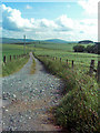
Track to Meadowbank farm
Upstream Cannie Burn.
Image: © Stanley Howe
Taken: 2 Apr 2009
0.23 miles
7
Cairndard
Looking downhill to the abandoned farm of Cairndard. Koncoakndy Hill is in the distance.
Image: © Anne Burgess
Taken: 5 Nov 2020
0.23 miles
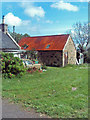
8
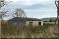
A Pre-fab
As we got close to Cairndard, I realised that the building looked very familiar. It's a pre-fab, short for prefabricated house. After the second world war there was a huge shortage of housing, and large numbers of prefabricated houses like these were quickly erected as a temporary solution to the housing shortage. I knew the type well because as a child I often visited one of my school friends who lived in a pre-fab just round the corner from my home. It was a bit surprising to find a single one out here well away from any other houses, and it would be interesting to know when it was erected here and why.
Compare this with Image and Image and see https://www.prefabmuseum.uk/content/history/one-arcon-story
Image: © Anne Burgess
Taken: 5 Nov 2020
0.23 miles
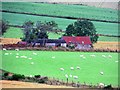
9
Sheep by Cairndard
Sheep grazing by a derelict looking croft at Cairndard.
Image: © Andrew Wood
Taken: 7 Aug 2019
0.23 miles
10
Looking across plough to Meadowbank
With Stonedike to the left.
Image: © Stanley Howe
Taken: 2 Apr 2009
0.24 miles