IMAGES TAKEN NEAR TO
Gourdas Place, TURRIFF, AB53 8RW
Introduction
This page details the photographs taken nearby to Gourdas Place, AB53 8RW by members of the Geograph project.
The Geograph project started in 2005 with the aim of publishing, organising and preserving representative images for every square kilometre of Great Britain, Ireland and the Isle of Man.

There are currently over 7.5m images from over14,400 individuals and you can help contribute to the project by visiting https://www.geograph.org.uk
Image Map
Images are licensed for reuse under creativecommons.org/licenses/by-sa/2.0
Notes
- Clicking on the map will re-center to the selected point.
- The higher the marker number, the further away the image location is from the centre of the postcode.
Image Listing (3 Images Found)
Images are licensed for reuse under creativecommons.org/licenses/by-sa/2.0
Image
Details
Distance
1
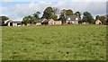
Gourdas Farm
This is one of several farms around here with similar names according to the 1:50,000 map, though the 1:25,000 map does distinguish them by name. The farm house is very traditional, with the main door in the centre of the front, flanked by matching windows and with a pair of dormer windows above.
Image: © Anne Burgess
Taken: 21 Sep 2007
0.08 miles
2
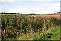
Gourdas
The tall plants of Rosebay Willowherb partly obscure the view of a double glacial meltwater channel in the land beyond.
Image: © Anne Burgess
Taken: 21 Sep 2007
0.14 miles
3
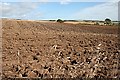
Gourdas
Newly ploughed land between Steinmanhill and Gourdas.
Image: © Anne Burgess
Taken: 21 Sep 2007
0.19 miles