IMAGES TAKEN NEAR TO
Fyvie, TURRIFF, AB53 8PY
Introduction
This page details the photographs taken nearby to AB53 8PY by members of the Geograph project.
The Geograph project started in 2005 with the aim of publishing, organising and preserving representative images for every square kilometre of Great Britain, Ireland and the Isle of Man.

There are currently over 7.5m images from over14,400 individuals and you can help contribute to the project by visiting https://www.geograph.org.uk
Image Map
Images are licensed for reuse under creativecommons.org/licenses/by-sa/2.0
Notes
- Clicking on the map will re-center to the selected point.
- The higher the marker number, the further away the image location is from the centre of the postcode.
Image Listing (7 Images Found)
Images are licensed for reuse under creativecommons.org/licenses/by-sa/2.0
Image
Details
Distance
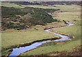
1
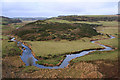
The meandering River Ythan viewed from the south.
A good example of the mature stages of the river Ythan near the Braes of Minnonie.
Image: © Des Colhoun
Taken: 10 Jan 2007
0.11 miles
2
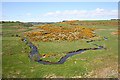
River Ythan
A magnificent meander of the River Ythan inside a meander of a glacial meltwater channel. Compare Image
Image: © Anne Burgess
Taken: 7 May 2009
0.12 miles
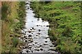
3
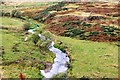
River Ythan
The Ythan flowing downstream to make a turn north by St. John's well.
Image: © Andrew Wood
Taken: 8 Oct 2016
0.13 miles
4
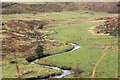
Ythan passes Mill Water
The Ythan flowing downstream; the Mill Water joins it just by the second bend of the meander.
Image: © Andrew Wood
Taken: 8 Oct 2016
0.14 miles
5
The Ythan to the west of the Braes of Minnonie.
Image: © Des Colhoun
Taken: 10 Jan 2007
0.19 miles
6
Crichie Burn
The relatively small burn of Crichie as it flows out of the Den to the bridge soon to join the Ythan.
Image: © Andrew Wood
Taken: 8 Oct 2016
0.20 miles
7
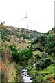
Den of Crichie
The Den with its burn and a windturbine in the region of Denhill farm behind.
Image: © Andrew Wood
Taken: 8 Oct 2016
0.23 miles