IMAGES TAKEN NEAR TO
Fyvie, TURRIFF, AB53 8LR
Introduction
This page details the photographs taken nearby to AB53 8LR by members of the Geograph project.
The Geograph project started in 2005 with the aim of publishing, organising and preserving representative images for every square kilometre of Great Britain, Ireland and the Isle of Man.

There are currently over 7.5m images from over14,400 individuals and you can help contribute to the project by visiting https://www.geograph.org.uk
Image Map
Images are licensed for reuse under creativecommons.org/licenses/by-sa/2.0
Notes
- Clicking on the map will re-center to the selected point.
- The higher the marker number, the further away the image location is from the centre of the postcode.
Image Listing (13 Images Found)
Images are licensed for reuse under creativecommons.org/licenses/by-sa/2.0
Image
Details
Distance
1
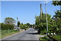
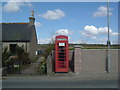
Woodhead: village approach
The B9005 runs through the village and eventually reaches Ellon.
Image: © Bill Harrison
Taken: 26 May 2018
0.03 miles
3
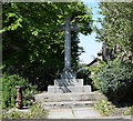
Restored mercat cross, Woodhead
Woodhead is now a sleepy commuter/retirement village but in the 17th Century was a burgh of barony (see: https://en.wikipedia.org/wiki/Burgh_of_barony ) and the centre of rural life in the area with a market and a tolbooth. The restored mercat cross (dated 1846) recalls its former importance although it's not clear how much is original.
Image: © Bill Harrison
Taken: 26 May 2018
0.08 miles
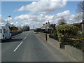
4
Woodhead Hall
The village hall and notice board at Woodhead with the spire of All Saints church just visible behind.
Image: © Andrew Wood
Taken: 28 Apr 2017
0.10 miles
5
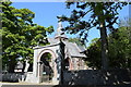
Woodhead Chapel
All Saints Church, near Fyvie. See http://www.windyhills.org/content/view/70/81/ for some history of the church, and the origins of the arch that was moved here from Kingsford near Alford in 1922.
Image: © Ian Brackenridge
Taken: Unknown
0.11 miles
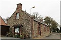
6
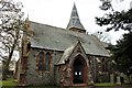
All Saints
The B listed Episcopal Church of All Saints at Woodhead.
Image: © Andrew Wood
Taken: 28 Apr 2017
0.12 miles
7
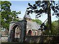
Gateway to All Saints Episcopal Church, Woodhead
The gateway arch with its pink marble columns apparently came from Kingsford House near Alford, some 30 km to the southwest.
Image: © Bill Harrison
Taken: 26 May 2018
0.12 miles
9
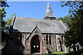
All Saints Episcopal Church, Woodhead
Built 1848 with the spire added in 1870 and B-listed (LB9624): http://portal.historicenvironment.scot/designation/LB9624 . The 'blue rag' masonry with red sandstone dressings is utterly different to typical Aberdeenshire granite.
Image: © Bill Harrison
Taken: 26 May 2018
0.13 miles
10
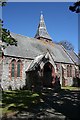
All Saints Church
A closer look at the church, which is Early English in style, though built in the 19th century. The architect was John Henderson. It belongs to the Scottish Episcopal Church.
Image: © Anne Burgess
Taken: 7 May 2009
0.13 miles