IMAGES TAKEN NEAR TO
Cuminestown, TURRIFF, AB53 8HX
Introduction
This page details the photographs taken nearby to AB53 8HX by members of the Geograph project.
The Geograph project started in 2005 with the aim of publishing, organising and preserving representative images for every square kilometre of Great Britain, Ireland and the Isle of Man.

There are currently over 7.5m images from over14,400 individuals and you can help contribute to the project by visiting https://www.geograph.org.uk
Image Map
Images are licensed for reuse under creativecommons.org/licenses/by-sa/2.0
Notes
- Clicking on the map will re-center to the selected point.
- The higher the marker number, the further away the image location is from the centre of the postcode.
Image Listing (4 Images Found)
Images are licensed for reuse under creativecommons.org/licenses/by-sa/2.0
Image
Details
Distance
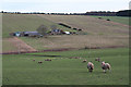
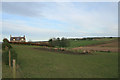
1
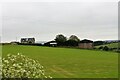
South Teuchar
A roadside farm above the Howe of Teuchar just south of Cumminestown.
Image: © Andrew Wood
Taken: 29 Jun 2021
0.04 miles
3
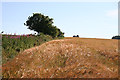
Barley Crop
Late afternoon sunshine gives a red-gold glow to this crop of barley. The Fireweed and trees on the left mark the line of what is shown on maps as a track, but is definitely not passable now.
Image: © Anne Burgess
Taken: 22 Jul 2014
0.16 miles