IMAGES TAKEN NEAR TO
Cuminestown, TURRIFF, AB53 8HR
Introduction
This page details the photographs taken nearby to AB53 8HR by members of the Geograph project.
The Geograph project started in 2005 with the aim of publishing, organising and preserving representative images for every square kilometre of Great Britain, Ireland and the Isle of Man.

There are currently over 7.5m images from over14,400 individuals and you can help contribute to the project by visiting https://www.geograph.org.uk
Image Map
Images are licensed for reuse under creativecommons.org/licenses/by-sa/2.0
Notes
- Clicking on the map will re-center to the selected point.
- The higher the marker number, the further away the image location is from the centre of the postcode.
Image Listing (8 Images Found)
Images are licensed for reuse under creativecommons.org/licenses/by-sa/2.0
Image
Details
Distance
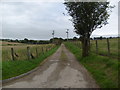
1
Downhill to Teuchar Lodge
The road downhill to Teuchar Lodge on the outskirts of Cuminestown with woodland on the left.
Image: © Andrew Wood
Taken: 21 Jul 2020
0.07 miles
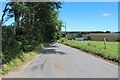
2
Ripening Barley
Teuchar Lodge is hidden behind the trees in the background.
Image: © Anne Burgess
Taken: 22 Jul 2014
0.15 miles
3
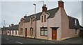
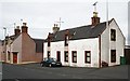
Houses in Cuminestown
I am intrigued by the changes in the colour of the harling on these houses in Main Street.
Image: © Anne Burgess
Taken: 21 Sep 2007
0.20 miles
4
House in Cuminestown
This is an attractive example of vernacular architecture. Interestingly, it is set a little back from the line of the rest of the houses in the street.
Image: © Anne Burgess
Taken: 21 Sep 2007
0.21 miles
5
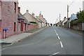
Cuminestown High Street
Cuminestown is one of the many planned villages built in Scotland between 1750 and 1850. These are characterised by broad straight streets in a rectangular plane, with the long elevations of houses facing the street.
Image: © Anne Burgess
Taken: 21 Sep 2007
0.22 miles
6
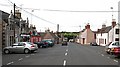
Cuminestown Main Street
A feature of planned villages like this one is a square which is usually intended to be the focal point of the village.
Image: © Anne Burgess
Taken: 21 Sep 2007
0.22 miles
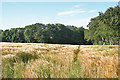
7
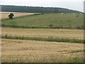
Farmland outside Cuminestown
A grass field with grazing cattle contrasts with the surrounding barley.
Image: © Richard Webb
Taken: 4 Aug 2011
0.24 miles