IMAGES TAKEN NEAR TO
TURRIFF, AB53 8ET
Introduction
This page details the photographs taken nearby to AB53 8ET by members of the Geograph project.
The Geograph project started in 2005 with the aim of publishing, organising and preserving representative images for every square kilometre of Great Britain, Ireland and the Isle of Man.

There are currently over 7.5m images from over14,400 individuals and you can help contribute to the project by visiting https://www.geograph.org.uk
Image Map
Images are licensed for reuse under creativecommons.org/licenses/by-sa/2.0
Notes
- Clicking on the map will re-center to the selected point.
- The higher the marker number, the further away the image location is from the centre of the postcode.
Image Listing (7 Images Found)
Images are licensed for reuse under creativecommons.org/licenses/by-sa/2.0
Image
Details
Distance
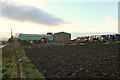
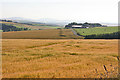
2
Near Backmill
The lie of the land conceals Backmill in a dip beyond the trees at extreme right. The field of bales is in the next square, but the foreground one, with cattle is in this square.
Image: © Anne Burgess
Taken: 22 Jul 2014
0.05 miles
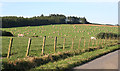
3
Backmill
Still more fields of barley, the ripening grain given a reddish tinge by the evening sunshine.
Image: © Anne Burgess
Taken: 22 Jul 2014
0.12 miles
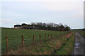
4
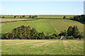
Mill of Backmill
The mill is sited on the Burn of Balquholly. A minor road links Backmill and Broadgreen via Mill of Backmill to the not-so-minor road above. The road junction is the narrow V-shaped feature above the cattle and to the right of the bales.
Image: © Anne Burgess
Taken: 22 Jul 2014
0.13 miles
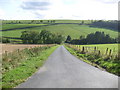
5
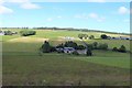
Mill of Backhill
The mill of Backhill in the howe of the Burn of Balquholly which presumably provided a power source. Backmill Farm can be seen on the right.
Image: © Andrew Wood
Taken: 21 Jul 2020
0.14 miles