IMAGES TAKEN NEAR TO
TURRIFF, AB53 8BP
Introduction
This page details the photographs taken nearby to AB53 8BP by members of the Geograph project.
The Geograph project started in 2005 with the aim of publishing, organising and preserving representative images for every square kilometre of Great Britain, Ireland and the Isle of Man.

There are currently over 7.5m images from over14,400 individuals and you can help contribute to the project by visiting https://www.geograph.org.uk
Image Map
Images are licensed for reuse under creativecommons.org/licenses/by-sa/2.0
Notes
- Clicking on the map will re-center to the selected point.
- The higher the marker number, the further away the image location is from the centre of the postcode.
Image Listing (6 Images Found)
Images are licensed for reuse under creativecommons.org/licenses/by-sa/2.0
Image
Details
Distance
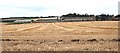
3
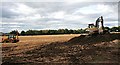
Extracting Topsoil
At least, that is what I was told was happening here. The topsoil is sold to housing developers who spread it on what will become the gardens of new houses.
Image: © Anne Burgess
Taken: 13 Sep 2007
0.13 miles
4
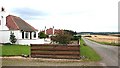
Gask Cottages
These look more like inter-war bungalows than traditional cottages. The diggers beyond are thought to be extracting topsoil for sale to housing developers.
Image: © Anne Burgess
Taken: 13 Sep 2007
0.22 miles
5
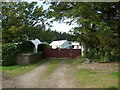
Gask
The grid line goes right through the farm buildings at Gask. The tall byre at right is in this square, but the sheds to the left are in the next square.
Image: © Anne Burgess
Taken: 13 Sep 2007
0.23 miles
6
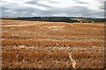
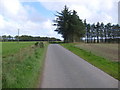
Upper Darra
Stubble fields against an interesting cloudscape.
Image: © Anne Burgess
Taken: 13 Sep 2007
0.23 miles