IMAGES TAKEN NEAR TO
Auchterless, TURRIFF, AB53 8BD
Introduction
This page details the photographs taken nearby to AB53 8BD by members of the Geograph project.
The Geograph project started in 2005 with the aim of publishing, organising and preserving representative images for every square kilometre of Great Britain, Ireland and the Isle of Man.

There are currently over 7.5m images from over14,400 individuals and you can help contribute to the project by visiting https://www.geograph.org.uk
Image Map
Images are licensed for reuse under creativecommons.org/licenses/by-sa/2.0
Notes
- Clicking on the map will re-center to the selected point.
- The higher the marker number, the further away the image location is from the centre of the postcode.
Image Listing (2 Images Found)
Images are licensed for reuse under creativecommons.org/licenses/by-sa/2.0
Image
Details
Distance
1
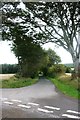
Templand Road
The access road to Templand.
Image: © Andrew Wood
Taken: 12 Sep 2011
0.12 miles
2
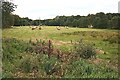
Bridge of Templand
This field is right by the River Ythan, and is probably prone to flooding in severe weather. The river flows along the far side of the field.
Image: © Anne Burgess
Taken: 13 Sep 2007
0.18 miles