IMAGES TAKEN NEAR TO
TURRIFF, AB53 8AQ
Introduction
This page details the photographs taken nearby to AB53 8AQ by members of the Geograph project.
The Geograph project started in 2005 with the aim of publishing, organising and preserving representative images for every square kilometre of Great Britain, Ireland and the Isle of Man.

There are currently over 7.5m images from over14,400 individuals and you can help contribute to the project by visiting https://www.geograph.org.uk
Image Map
Images are licensed for reuse under creativecommons.org/licenses/by-sa/2.0
Notes
- Clicking on the map will re-center to the selected point.
- The higher the marker number, the further away the image location is from the centre of the postcode.
Image Listing (8 Images Found)
Images are licensed for reuse under creativecommons.org/licenses/by-sa/2.0
Image
Details
Distance
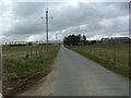
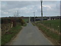
2

Minor road near Backhill of Hatton heading west
Image: © JThomas
Taken: 26 Sep 2010
0.11 miles
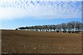
3
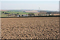
Backhill of Hatton
Looking across ploughed fields to Backhill of Hatton. Further way is Charlesfield, all dominated by the wind turbines on distant Gordonstown Hill.
Image: © Anne Burgess
Taken: 9 Apr 2015
0.12 miles
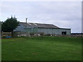
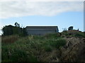
7
Field by Hatton
A cultivated field near Backhill of Hatton Farm.
Image: © Andrew Wood
Taken: 17 Apr 2021
0.22 miles