IMAGES TAKEN NEAR TO
Fisherie, TURRIFF, AB53 5QB
Introduction
This page details the photographs taken nearby to AB53 5QB by members of the Geograph project.
The Geograph project started in 2005 with the aim of publishing, organising and preserving representative images for every square kilometre of Great Britain, Ireland and the Isle of Man.

There are currently over 7.5m images from over14,400 individuals and you can help contribute to the project by visiting https://www.geograph.org.uk
Image Map
Images are licensed for reuse under creativecommons.org/licenses/by-sa/2.0
Notes
- Clicking on the map will re-center to the selected point.
- The higher the marker number, the further away the image location is from the centre of the postcode.
Image Listing (7 Images Found)
Images are licensed for reuse under creativecommons.org/licenses/by-sa/2.0
Image
Details
Distance
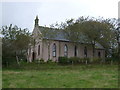
2
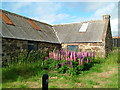
Former Kirk
I'm not sure what variety of kirk this was. It has been converted into a house.
Image: © Anne Burgess
Taken: 2 Jul 2009
0.09 miles
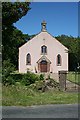
3
Former Kirk
Interestingly, the contemporary maps, even online, still mark this as a kirk, though it has been a house for some time. See Image
Image: © Anne Burgess
Taken: 22 Jul 2014
0.09 miles
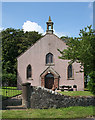
5
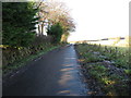
Minor road signed to Walkerhill
Looking north-westward. A private house that used to be a church is over the hedge on the left. An 1870 map has it as a Congregational Chapel.
Image: © Peter Wood
Taken: 18 Nov 2019
0.12 miles
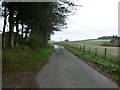
7
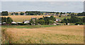
Lower Cook
The origin of the name Cook for a place becomes even more intriguing when one notes that the Burn of Cake runs through it. The crop is barley.
Image: © Anne Burgess
Taken: 22 Jul 2014
0.14 miles