IMAGES TAKEN NEAR TO
TURRIFF, AB53 5PU
Introduction
This page details the photographs taken nearby to AB53 5PU by members of the Geograph project.
The Geograph project started in 2005 with the aim of publishing, organising and preserving representative images for every square kilometre of Great Britain, Ireland and the Isle of Man.

There are currently over 7.5m images from over14,400 individuals and you can help contribute to the project by visiting https://www.geograph.org.uk
Image Map
Images are licensed for reuse under creativecommons.org/licenses/by-sa/2.0
Notes
- Clicking on the map will re-center to the selected point.
- The higher the marker number, the further away the image location is from the centre of the postcode.
Image Listing (2 Images Found)
Images are licensed for reuse under creativecommons.org/licenses/by-sa/2.0
Image
Details
Distance
2
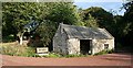
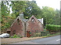
Craigston Sawmill
From its position by the burn and the OS map, I thought this was the Mill of Craigston. However I am assured that it was in fact the sawmill, and that the Mill is further on.
Image: © Anne Burgess
Taken: 21 Sep 2007
0.08 miles