IMAGES TAKEN NEAR TO
Brackens Place, TURRIFF, AB53 4UB
Introduction
This page details the photographs taken nearby to Brackens Place, AB53 4UB by members of the Geograph project.
The Geograph project started in 2005 with the aim of publishing, organising and preserving representative images for every square kilometre of Great Britain, Ireland and the Isle of Man.

There are currently over 7.5m images from over14,400 individuals and you can help contribute to the project by visiting https://www.geograph.org.uk
Image Map
Images are licensed for reuse under creativecommons.org/licenses/by-sa/2.0
Notes
- Clicking on the map will re-center to the selected point.
- The higher the marker number, the further away the image location is from the centre of the postcode.
Image Listing (5 Images Found)
Images are licensed for reuse under creativecommons.org/licenses/by-sa/2.0
Image
Details
Distance
1
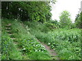
Steps from the cutting
There is a well used footpath on the old railway line. Here, the path leaves the cutting and joins a minor road that leads to the B9025.
Image: © don cload
Taken: 26 May 2011
0.17 miles
2
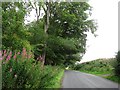
Small woodland, Knockiemill
Road and wood between Turriff and the River Deveron.
Image: © Richard Webb
Taken: 5 Aug 2011
0.21 miles
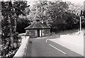
3
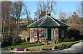
Toll House
The quaint hexagonal toll house stands at the north end of the bridge over the River Deveron at Turriff. The bridge and toll house were built in 1826, and the architect was William Robertson. The toll house is now used by the local angling association.
Image: © Anne Burgess
Taken: 1 May 2013
0.25 miles
4
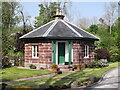
Former tollhouse
Surveyed by the Milestone Society. This hexagonal shaped former tollhouse built of dressed stone with a slate roof is called Knockiemill Lodge. It is on the B9025 Turriff to Aberchirder road and is at the east end of the bridge over the River Deveron. Tollhouses near to a bridge are often seen in Scotland. It was renovated in 1996.
Image: © Chris Minto
Taken: 19 May 2014
0.25 miles
5
Former tollhouse
Surveyed by the Milestone Society. This is a photograph taken in the 1980s of the tollhouse at the east end of the bridge over the River Deveron
Image: © J Malden
Taken: 1 Jun 1982
0.25 miles