IMAGES TAKEN NEAR TO
Putachie Path, TURRIFF, AB53 4SJ
Introduction
This page details the photographs taken nearby to Putachie Path, AB53 4SJ by members of the Geograph project.
The Geograph project started in 2005 with the aim of publishing, organising and preserving representative images for every square kilometre of Great Britain, Ireland and the Isle of Man.

There are currently over 7.5m images from over14,400 individuals and you can help contribute to the project by visiting https://www.geograph.org.uk
Image Map
Images are licensed for reuse under creativecommons.org/licenses/by-sa/2.0
Notes
- Clicking on the map will re-center to the selected point.
- The higher the marker number, the further away the image location is from the centre of the postcode.
Image Listing (101 Images Found)
Images are licensed for reuse under creativecommons.org/licenses/by-sa/2.0
Image
Details
Distance
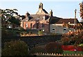
1
Church of Turriff
Graves next to houses
Image: © stephen samson
Taken: 11 Nov 2006
0.00 miles
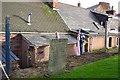
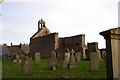
2
Putachie Path
I have no idea where this odd-sounding name came from. Its traditional houses contrast with the modern bungalows and council houses beyond.
Image: © Anne Burgess
Taken: 24 Oct 2007
0.01 miles
3
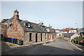
Putachie Path, Turriff
The unusually-named street plunges sharply down past the early 19th Century C-listed cottages: http://portal.historicenvironment.scot/designation/LB42165 (listed building designation LB42165).
Image: © Bill Harrison
Taken: 17 Sep 2016
0.01 miles
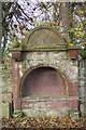
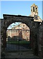
4
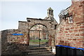
Arch and gateway to St Congan's kirkyard
Late 17th Century and B-listed (LB42164): http://portal.historicenvironment.scot/designation/LB42164 .
Image: © Bill Harrison
Taken: 17 Sep 2016
0.01 miles
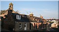
5
Putachie Path
The gable of the old kirk, its gilded clock catching the morning sun, stands above the red sandstone houses of Putchie Path. Seen across the gardens of modern council housing.
Image: © Anne Burgess
Taken: 24 Oct 2007
0.01 miles
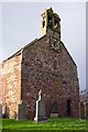
6

Church of Turriff
Remains of the medieval church of Turriff. In December 1861 portions of the choir were taken away, and on removing the stones from a window in the south wall, there appeared on the splay of one of the sides a human figure painted on the plaster in bright colours. Another painting was found on the other splay but was unfortunately never recorded and it was broken up and destroyed!
Image: © stephen samson
Taken: 11 Nov 2006
0.01 miles
7
Church of Turriff
Remains of the medieval Church of Turriff. In December 1861 portions of the choir were taken away, and on removing the stones from a window in the south wall, there appeared on the splay of one of the sides a human figure painted on the plaster in bright colours. Another painting was found on the other splay but was unfortunately never recorded and it was broken up and destroyed!
Image: © stephen samson
Taken: 11 Nov 2006
0.01 miles
8
Church of Turriff
Remains of the medieval Church of Turriff. In December 1861 portions of the choir were taken away, and on removing the stones from a window in the south wall, there appeared on the splay of one of the sides a human figure painted on the plaster in bright colours. Another painting was found on the other splay but was unfortunately never recorded and it was broken up and destroyed!!
Image: © stephen samson
Taken: 11 Nov 2006
0.01 miles
9
Church of Turriff
Remains of the medieval Church of Turriff. In December 1861 portions of the choir were taken away, and on removing the stones from a window in the south wall, there appeared on the splay of one of the sides a human figure painted on the plaster in bright colours. Another painting was found on the other splay but was unfortunately never recorded and it was broken up and destroyed!!
Image: © stephen samson
Taken: 11 Nov 2006
0.01 miles
10
Gate to St Congan's Kirkyard
A sandstone archway and wrought iron gate give access to the old kirkyard.
Image: © Anne Burgess
Taken: 24 Oct 2007
0.02 miles