IMAGES TAKEN NEAR TO
TURRIFF, AB53 4GX
Introduction
This page details the photographs taken nearby to AB53 4GX by members of the Geograph project.
The Geograph project started in 2005 with the aim of publishing, organising and preserving representative images for every square kilometre of Great Britain, Ireland and the Isle of Man.

There are currently over 7.5m images from over14,400 individuals and you can help contribute to the project by visiting https://www.geograph.org.uk
Image Map
Images are licensed for reuse under creativecommons.org/licenses/by-sa/2.0
Notes
- Clicking on the map will re-center to the selected point.
- The higher the marker number, the further away the image location is from the centre of the postcode.
Image Listing (5 Images Found)
Images are licensed for reuse under creativecommons.org/licenses/by-sa/2.0
Image
Details
Distance
1
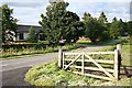
Clunie
According to older maps there was a school at this road junction, but it has clearly been replaced by modern bungalows.
Image: © Anne Burgess
Taken: 29 Jun 2007
0.01 miles
2
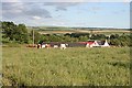
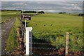
Damfolds
Judging by the length of the grass in this field, these cattle have only recently been put into it.
Image: © Anne Burgess
Taken: 29 Jun 2007
0.08 miles
5
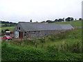
Newton of Clunie
One of several farms on the estate of Clunie, all on the south and west slopes of Clunie Hill.
Image: © Anne Burgess
Taken: 29 Jun 2007
0.22 miles