IMAGES TAKEN NEAR TO
Sauchen, INVERURIE, AB51 7NS
Introduction
This page details the photographs taken nearby to AB51 7NS by members of the Geograph project.
The Geograph project started in 2005 with the aim of publishing, organising and preserving representative images for every square kilometre of Great Britain, Ireland and the Isle of Man.

There are currently over 7.5m images from over14,400 individuals and you can help contribute to the project by visiting https://www.geograph.org.uk
Image Map
Images are licensed for reuse under creativecommons.org/licenses/by-sa/2.0
Notes
- Clicking on the map will re-center to the selected point.
- The higher the marker number, the further away the image location is from the centre of the postcode.
Image Listing (14 Images Found)
Images are licensed for reuse under creativecommons.org/licenses/by-sa/2.0
Image
Details
Distance
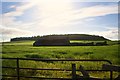
1
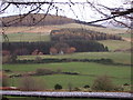
Shepherd's Croft
Seen from Corrennie Forest track; with Knockfullertree hill beyond.
Image: © Stanley Howe
Taken: 6 Nov 2007
0.15 miles
2
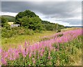
Shepherd's Croft near Rinalloch
Viewed from B993, over the Stony Burn whose bank was overgrown with Rosebay willow-herb.
Image: © Stanley Howe
Taken: 22 Jul 2018
0.15 miles
3
Shepherd's Croft
From Millbank to Learney road.
Image: © Stanley Howe
Taken: 26 Mar 2009
0.16 miles
4
Wetland by Shepherd's Croft
Wetland and brush between Rinalloch and Shepherd's Croft caused by the headwaters of the emergent Douglas Burn.
Image: © Andrew Wood
Taken: 28 Aug 2020
0.20 miles
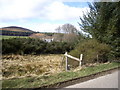
5
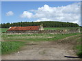
Derelict farmstead
Off road from Learney to Millbank. Knockfullertree Wood in background.
Image: © Stanley Howe
Taken: 18 May 2007
0.21 miles
6

Boundary stone by B933
Near a ruined croft (in background). The right hand face has the letter 'M' inscribed; would this perhaps be for MILLBANK, the next hamlet/parish to the left?
Image: © Stanley Howe
Taken: 29 Aug 2011
0.22 miles
7
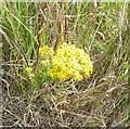
Ragwort in July
Close to Shepherd's Croft, where the B993 crosses the overgrown Stony Burn.
Image: © Stanley Howe
Taken: 22 Jul 2018
0.23 miles
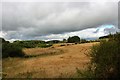
8
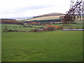
View east over Tillyfro
Towards Knockfullertree hill [NJ6508] at 297m asl.
Image: © Stanley Howe
Taken: 6 Nov 2007
0.24 miles
9
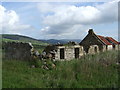
Derelict farmstead
Although now isolated in the middle of a field. from the rear the near part has the features of a croft. It is possible that before the nearby road was constructed, the wagonway passed this side of the building. Other ruins in the area even suggest this may have been a crofting community.
Image: © Stanley Howe
Taken: 31 May 2007
0.24 miles
10
Ruin by Knockfullertree
A roadside ruin under Knockfullertree Wood.
Image: © Andrew Wood
Taken: 7 Jul 2010
0.24 miles