IMAGES TAKEN NEAR TO
Monymusk, INVERURIE, AB51 7JA
Introduction
This page details the photographs taken nearby to AB51 7JA by members of the Geograph project.
The Geograph project started in 2005 with the aim of publishing, organising and preserving representative images for every square kilometre of Great Britain, Ireland and the Isle of Man.

There are currently over 7.5m images from over14,400 individuals and you can help contribute to the project by visiting https://www.geograph.org.uk
Image Map
Images are licensed for reuse under creativecommons.org/licenses/by-sa/2.0
Notes
- Clicking on the map will re-center to the selected point.
- The higher the marker number, the further away the image location is from the centre of the postcode.
Image Listing (21 Images Found)
Images are licensed for reuse under creativecommons.org/licenses/by-sa/2.0
Image
Details
Distance
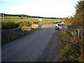
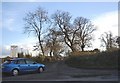
3

Minor road at Dalbraidie
Looking south-eastward.
Image: © Peter Wood
Taken: 15 Oct 2019
0.03 miles
5
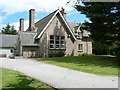
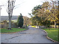
Sir Arthur Grant Centre
An outdoor activities centre near the village of Monymusk, that has modified and adapted for use by both able-bodied and disabled persons.
Image: © James Allan
Taken: 18 Jun 2008
0.10 miles
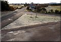
6
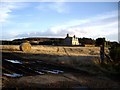
Access to Tillywater
From Monymusk road.
Image: © Stanley Howe
Taken: 15 Nov 2007
0.11 miles
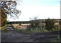
8
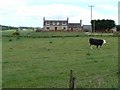
Road to Donview and Lords Throat
The farm buildings in the distance is Dalbraidie (in NJ6816).
Image: © Gilbert Scott
Taken: 19 Nov 2006
0.11 miles
10
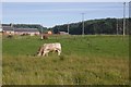
Lane to Delab
A dairy farm on the Monymusk Estates.
Image: © Stanley Howe
Taken: 15 Nov 2008
0.14 miles