IMAGES TAKEN NEAR TO
Pitcaple, INVERURIE, AB51 5DY
Introduction
This page details the photographs taken nearby to AB51 5DY by members of the Geograph project.
The Geograph project started in 2005 with the aim of publishing, organising and preserving representative images for every square kilometre of Great Britain, Ireland and the Isle of Man.

There are currently over 7.5m images from over14,400 individuals and you can help contribute to the project by visiting https://www.geograph.org.uk
Image Map
Images are licensed for reuse under creativecommons.org/licenses/by-sa/2.0
Notes
- Clicking on the map will re-center to the selected point.
- The higher the marker number, the further away the image location is from the centre of the postcode.
Image Listing (6 Images Found)
Images are licensed for reuse under creativecommons.org/licenses/by-sa/2.0
Image
Details
Distance
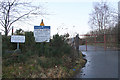
1
Buzzard Access Road
The access road to the Buzzard Cafe or Pitscurry project. The farm further up in Damhead.
Image: © Andrew Wood
Taken: 7 Aug 2020
0.02 miles
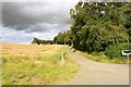
2
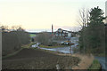
Pitscurry Project
The Pitscurry Project provides work and training for people with learning difficulties. It includes a garden and a popular café.
Image: © Anne Burgess
Taken: 29 Oct 2019
0.03 miles
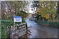
3
Entrance to Pitcaple Quarry
Firmly closed on a Tuesday afternoon.
Image: © Anne Burgess
Taken: 29 Oct 2019
0.05 miles
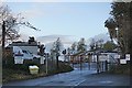
5
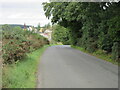
C76C (Aberdeenshire) Road near Pitcaple
The C76C road heading west towards Pitcaple Quarry.
Image: © Scott Cormie
Taken: 4 Sep 2021
0.08 miles