IMAGES TAKEN NEAR TO
Pitcaple, INVERURIE, AB51 5DP
Introduction
This page details the photographs taken nearby to AB51 5DP by members of the Geograph project.
The Geograph project started in 2005 with the aim of publishing, organising and preserving representative images for every square kilometre of Great Britain, Ireland and the Isle of Man.

There are currently over 7.5m images from over14,400 individuals and you can help contribute to the project by visiting https://www.geograph.org.uk
Image Map
Images are licensed for reuse under creativecommons.org/licenses/by-sa/2.0
Notes
- Clicking on the map will re-center to the selected point.
- The higher the marker number, the further away the image location is from the centre of the postcode.
Image Listing (10 Images Found)
Images are licensed for reuse under creativecommons.org/licenses/by-sa/2.0
Image
Details
Distance
1
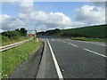
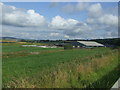
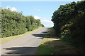
A96, Drimmies
Heading south east towards Aberdeen.
Image: © JThomas
Taken: 20 Jul 2014
0.09 miles
2
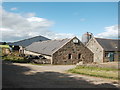
Drimmies Farm
A large dairy farm: a row of Friesian cows can just be discerned in the barn to the left.
Image: © Bill Harrison
Taken: 16 Jul 2017
0.10 miles
3
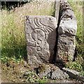
Drimmies' Symbol Stone
A fine Pictish symbol stone showing comb-and-mirror, "ogee" and fragment of a horseshoe symbol and built into the wall of a farm. Its origins are unknown, but it's been in this location for at least 150 years. For more details see, Allen and Anderson, "Early Christian Monuments of Scotland", vol. 3, pp. 162-163, available as a free download from archive.org.
Image: © Bill Harrison
Taken: 16 Jul 2017
0.10 miles
4
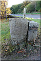
Drimmies Pictish Stone
The stone was found and built into the wall of a byre, but by the end of the 19th century it had been moved into the garden wall. The carvings have been dated to the 7th century, and include a serpentine symbol, mirror and comb.
Image: © Anne Burgess
Taken: 29 Oct 2019
0.10 miles
8
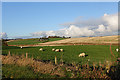
Sheep at Drimmies
Grazing in a field beside the large byre at Drimmies. The buildings on the hill in the distance are at Harlaw.
Image: © Anne Burgess
Taken: 29 Oct 2019
0.17 miles
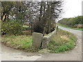
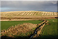
9
The auld road
Former alignment of the A96, now a quiet dead-end serving a couple of farms. The new alignment of the main Aberdeen to Inverness road was opened in the 1990s about 100 metres to the right of the photo.
Image: © Bill Harrison
Taken: 16 Jul 2017
0.18 miles
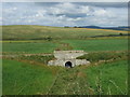
10
Strathnaterick Burn
The burn passes Balquhain and then joins the River Urie her at Drimmies.
Image: © Anne Burgess
Taken: 29 Oct 2019
0.21 miles