IMAGES TAKEN NEAR TO
Meikle Wartle, INVERURIE, AB51 5AN
Introduction
This page details the photographs taken nearby to AB51 5AN by members of the Geograph project.
The Geograph project started in 2005 with the aim of publishing, organising and preserving representative images for every square kilometre of Great Britain, Ireland and the Isle of Man.

There are currently over 7.5m images from over14,400 individuals and you can help contribute to the project by visiting https://www.geograph.org.uk
Image Map
Images are licensed for reuse under creativecommons.org/licenses/by-sa/2.0
Notes
- Clicking on the map will re-center to the selected point.
- The higher the marker number, the further away the image location is from the centre of the postcode.
Image Listing (2 Images Found)
Images are licensed for reuse under creativecommons.org/licenses/by-sa/2.0
Image
Details
Distance
1
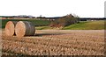
Windyhills and Mill of Wartle
Looking across the fields from near Southside, Mill of Wartle is the nearer farm, among the trees, and Windyhills is to its left, on the opposite bank of the Burn of Wartle.
Image: © Anne Burgess
Taken: 27 Nov 2008
0.03 miles
2
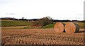
The Burn of Wartle
The burn flows in the dip in the ground to the left. The prominent farm beyond is Windyhills.
Image: © Anne Burgess
Taken: 27 Nov 2008
0.09 miles