IMAGES TAKEN NEAR TO
Elphinstone Road, INVERURIE, AB51 3UF
Introduction
This page details the photographs taken nearby to Elphinstone Road, AB51 3UF by members of the Geograph project.
The Geograph project started in 2005 with the aim of publishing, organising and preserving representative images for every square kilometre of Great Britain, Ireland and the Isle of Man.

There are currently over 7.5m images from over14,400 individuals and you can help contribute to the project by visiting https://www.geograph.org.uk
Image Map
Images are licensed for reuse under creativecommons.org/licenses/by-sa/2.0
Notes
- Clicking on the map will re-center to the selected point.
- The higher the marker number, the further away the image location is from the centre of the postcode.
Image Listing (38 Images Found)
Images are licensed for reuse under creativecommons.org/licenses/by-sa/2.0
Image
Details
Distance
1
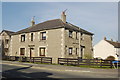
Maisonette, Elphinstone Road, Port Elphinstone
An unusual 1930s design for Inverurie.
Image: © Bill Harrison
Taken: 26 Mar 2012
0.02 miles
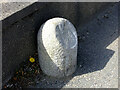
3
Old milestone on the B993, Port Elphinstone
On the west side of the B993 (old A96) at the southern end of Port Elphinstone is the stone 15 miles from Aberdeen https://www.geograph.org.uk/photo/6821866. The road towards Kemnay is now cut off by the by-pass.
Image: © Chris McBrien
Taken: 17 Apr 2021
0.07 miles
4
Old milestone on the B993, Port Elphinstone
A close-up of the 15 miles from Aberdeen granite post on the B993 at the southern end of Port Elphinstone. Why Port Elphinstone when the town is not on the coast? It was one end of the short-lived canal from Aberdeen. It was operative for about 40 years before railways were built.
Context view http://www.geograph.org.uk/photo/6821862.
Image: © Chris McBrien
Taken: 17 Apr 2021
0.07 miles
5
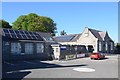
Port Elphinstone Primary School
Built 1870 and extended at various times. According to the school website, electricity was connected in 1950 and central heating was installed in 1954. School roll (2019-20): 87 in five composite classes.
Image: © Bill Harrison
Taken: 31 May 2020
0.07 miles
6
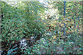
Port Elphinstone Canal
The canal is very much obscured by foliage here, but there is a glimpse of the water surface through the leaves.
Image: © Anne Burgess
Taken: 29 Sep 2017
0.10 miles
7
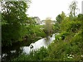
Aberdeenshire Canal, Port Elphinstone
The Canal was largely overbuilt in the 1840s when the Great North of Scotland Railway purchased it and built its Aberdeen to Inverurie line along its course. This section remained in water as a feeder to the Broomend mills.
Image: © Alan Murray-Rust
Taken: 22 May 2022
0.10 miles
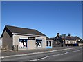
8
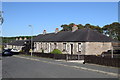
Single-storey terraces, Kemnay Road, Port Elphistone
They probably once housed workers at Inverurie Paper Mill.
Image: © Bill Harrison
Taken: 31 May 2020
0.13 miles
9
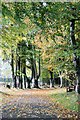
Blythewood Avenue
An avenue of mature trees between the former Blythewood care home and Port Elphinstone Primary School.
Image: © Andrew Wood
Taken: 16 Oct 2016
0.14 miles
10
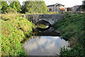
Bridge over the Lade
This is the original bridge that crossed the mill lade just before it joins the canal.
Image: © Anne Burgess
Taken: 29 Sep 2017
0.14 miles