IMAGES TAKEN NEAR TO
Laing Court, INVERURIE, AB51 3RP
Introduction
This page details the photographs taken nearby to Laing Court, AB51 3RP by members of the Geograph project.
The Geograph project started in 2005 with the aim of publishing, organising and preserving representative images for every square kilometre of Great Britain, Ireland and the Isle of Man.

There are currently over 7.5m images from over14,400 individuals and you can help contribute to the project by visiting https://www.geograph.org.uk
Image Map
Images are licensed for reuse under creativecommons.org/licenses/by-sa/2.0
Notes
- Clicking on the map will re-center to the selected point.
- The higher the marker number, the further away the image location is from the centre of the postcode.
Image Listing (39 Images Found)
Images are licensed for reuse under creativecommons.org/licenses/by-sa/2.0
Image
Details
Distance
1
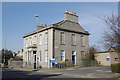
Former Union Bank...
...at the corner of the High Street and Old Station Road. Built ca. 1857 and B-listed: http://www.britishlistedbuildings.co.uk/sc-35395-80-high-street-
Image: © Bill Harrison
Taken: 26 Mar 2012
0.04 miles
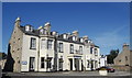
2
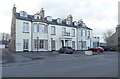
Kintore Arms Hotel
On the High Street (B9001), Iverurie. Dates from 1855.
Image: © Stanley Howe
Taken: 22 Feb 2018
0.05 miles
3

Kintore Arms Hotel
Arms above the main entrance
Image: © Richard Webb
Taken: 6 Aug 2011
0.05 miles
5
The Kintore Arms Hotel, High Street, Inverurie
For the impressive sculptured coat-of-arms above the door, see: http://www.geograph.org.uk/photo/2546302 . For the motto, see:
http://www.geograph.org.uk/photo/2931681 .
Image: © Bill Harrison
Taken: 19 Aug 2012
0.07 miles
6
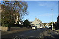
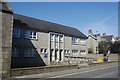
High Street, Inverurie (B9001)
Heading north.
Image: © JThomas
Taken: 9 Nov 2013
0.07 miles
7
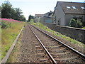
Inverurie 1st railway station (site), Aberdeenshire, 2014
Opened in 1854 by the Great North of Scotland Railway on what is today the line from Aberdeen to Inverness, this station closed in 1902 when it was replaced by the current station, some 800 metres to the north.
View south towards Kintore and Aberdeen from a public crossing. From old maps, it would appear to have had three platform faces with an island platform to the left and a further platform and main building to the right. No trace apparently remains.
Five years after this image was taken, the line was redoubled again.
Image: © Nigel Thompson
Taken: 25 Jul 2014
0.08 miles

9
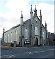
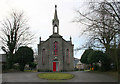
St Andrews Parish Church, Inverurie
Church of Scotland; on the High Street (B9001). See more details at http://www.scottishchurches.org.uk/sites/site/id/4135/name/St+Andrew%27s+Church%2C+Inverurie+Inverurie+Grampian
Image: © Stanley Howe
Taken: 22 Feb 2018
0.08 miles