IMAGES TAKEN NEAR TO
Kintore, INVERURIE, AB51 0TN
Introduction
This page details the photographs taken nearby to AB51 0TN by members of the Geograph project.
The Geograph project started in 2005 with the aim of publishing, organising and preserving representative images for every square kilometre of Great Britain, Ireland and the Isle of Man.

There are currently over 7.5m images from over14,400 individuals and you can help contribute to the project by visiting https://www.geograph.org.uk
Image Map
Images are licensed for reuse under creativecommons.org/licenses/by-sa/2.0
Notes
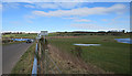
- Clicking on the map will re-center to the selected point.
- The higher the marker number, the further away the image location is from the centre of the postcode.
Image Listing (34 Images Found)
Images are licensed for reuse under creativecommons.org/licenses/by-sa/2.0
Image
Details
Distance
1
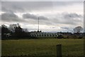
Kintore Bridge
The bridge over the Don at Kintore.
Image: © Andrew Wood
Taken: 23 Feb 2009
0.03 miles
2

Bridge of Don
Not to be confused with the Aberdeen city suburb of the same name! This Bridge of Don spans the River Don at Kintore.
Image: © Anne Burgess
Taken: 9 Apr 2018
0.05 miles
3
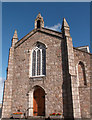
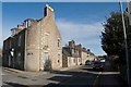
Kintore Kirk
In the grounds there are some ancient Pictish carved stones
Image: © pamela
Taken: 21 Sep 2004
0.05 miles
4
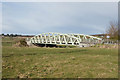
Bridge over the Don
A modern structure dating from ca. 1986. See here for more: http://www.kintore.org.uk/history.htm
Image: © Bill Harrison
Taken: 1 Apr 2010
0.05 miles
5
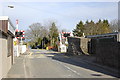
Level crossing (automatic half barriers)
The Aberdeen-Inverurie single line crosses the B977 to Hatton
Image: © Bill Harrison
Taken: 1 Apr 2010
0.05 miles
7
River Don
Looking downstream from the Bridge of Don at Kintore.
Image: © Anne Burgess
Taken: 9 Apr 2018
0.08 miles
8
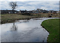
River Don at Kintore
It's not obvious from this view, but the village is cut off from the river bank by the railway which runs along behind the houses seen here.
Image: © Anne Burgess
Taken: 9 Apr 2018
0.09 miles
9
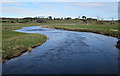
River Don
The River Don meanders through its floodplain. This is a meander close to the village of Kintore, but separated from the village by the railway. The map names this reach of the river as Burnmouth Pot.
Image: © Anne Burgess
Taken: 9 Apr 2018
0.09 miles
10
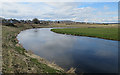
Road in a Meander
Traffic on the B977 road approaches the Bridge of Don, which is on the outside of a meander. The water visible to the left of the cars is upstream, and that on the far right is downstream.
Image: © Anne Burgess
Taken: 9 Apr 2018
0.11 miles