IMAGES TAKEN NEAR TO
Keith Hall, INVERURIE, AB51 0LG
Introduction
This page details the photographs taken nearby to AB51 0LG by members of the Geograph project.
The Geograph project started in 2005 with the aim of publishing, organising and preserving representative images for every square kilometre of Great Britain, Ireland and the Isle of Man.

There are currently over 7.5m images from over14,400 individuals and you can help contribute to the project by visiting https://www.geograph.org.uk
Image Map
Images are licensed for reuse under creativecommons.org/licenses/by-sa/2.0
Notes
- Clicking on the map will re-center to the selected point.
- The higher the marker number, the further away the image location is from the centre of the postcode.
Image Listing (6 Images Found)
Images are licensed for reuse under creativecommons.org/licenses/by-sa/2.0
Image
Details
Distance
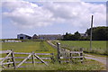
2
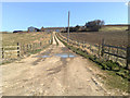
Crownhead Farm
Muddy and potholed the first impression of Crownhead seems to give only a taste of what is to follow.
Image: © Andrew Wood
Taken: 11 Oct 2008
0.22 miles
4
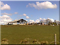
Backwaird Farm
A typical, somewhat sprawling, Aberdeenshire farm.
Image: © Bill Harrison
Taken: 27 Jun 2010
0.23 miles
5
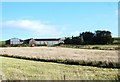
Backwaird Farm
Opposite Tillykerrie and almost anonymous is the farm of Backwaird.
Image: © Andrew Wood
Taken: 11 Oct 2008
0.24 miles