IMAGES TAKEN NEAR TO
Loanhead Park, INVERURIE, AB51 0JF
Introduction
This page details the photographs taken nearby to Loanhead Park, AB51 0JF by members of the Geograph project.
The Geograph project started in 2005 with the aim of publishing, organising and preserving representative images for every square kilometre of Great Britain, Ireland and the Isle of Man.

There are currently over 7.5m images from over14,400 individuals and you can help contribute to the project by visiting https://www.geograph.org.uk
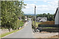
Image Map
Images are licensed for reuse under creativecommons.org/licenses/by-sa/2.0
Notes
- Clicking on the map will re-center to the selected point.
- The higher the marker number, the further away the image location is from the centre of the postcode.
Image Listing (66 Images Found)
Images are licensed for reuse under creativecommons.org/licenses/by-sa/2.0
Image
Details
Distance
1
Road into Daviot village
Note the traffic calming chicanes.
Image: © Bill Harrison
Taken: 16 Jul 2017
0.08 miles
2
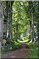
Birch Tree Walk
The imposing Avenue of trees leading north at the start of Birch Tree Walk on the Daviot Circular Walk.
Image: © Andrew Wood
Taken: 30 Jun 2020
0.15 miles
3
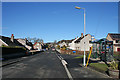
Daviot
This, the newer part of the village, boasts two of the village amenities in the shape of the bus stop of telephone kiosk. There are also a kirk, a school and a pub, not in this view.
Image: © Anne Burgess
Taken: 18 Feb 2016
0.15 miles
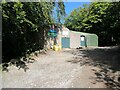
5
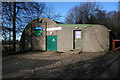
Daviot Scout Hut
Evidently developed from a second world war style nissen or similar hut.
Image: © Anne Burgess
Taken: 18 Feb 2016
0.16 miles
6
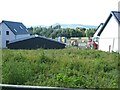
New building at Daviot
A lot of house building is going on at Daviot to take advantage of the magnificent views of the Bennachie group of hills which dominates the skyline over a large part of Aberdeenshire.
Image: © Oliver Dixon
Taken: 11 Aug 2023
0.17 miles
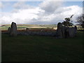
7
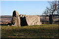
Loanhead of Daviot: stone circle
A large stone circle of 10 stones with a massive recumbent set between 2 upright flanking stones.
More details at: http://www.aberdeenshire.gov.uk/archaeology/sites/stonecircles/loanhead.asp
Image: © Martyn Gorman
Taken: 26 Aug 2010
0.18 miles
8
Loanhead of Daviot Stone Circle
Local high point gives a great view out across the Garioch.
Image: © John Haynes
Taken: 25 Oct 2003
0.18 miles
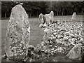
9
Loanhead of Daviot Recumbent Stone Circle (8)
The west flanker is taller than the recumbent, but the east flanker is of similar height and concealed by the recumbent in this view. To the right is the first orthostat of the circle. See https://canmore.org.uk/site/18789/loanhead-of-daviot for more details. Image Image] is a closer view of the recumbent setting in brighter light.
Image: © Anne Burgess
Taken: 18 Feb 2016
0.19 miles
10
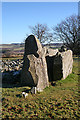
Loanhead of Daviot Recumbent Stone Circle (7)
Closest to the camera is the west flanker, which had been broken but has been repaired. The recumbent, next to it, has split vertically to form two separate slabs. Image] is another view of the spilt, in better light. See https://canmore.org.uk/site/18789/loanhead-of-daviot for more details. Image]
Image: © Anne Burgess
Taken: 18 Feb 2016
0.19 miles