IMAGES TAKEN NEAR TO
Fairfield Place, INVERURIE, AB51 0FJ
Introduction
This page details the photographs taken nearby to Fairfield Place, AB51 0FJ by members of the Geograph project.
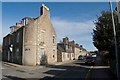
The Geograph project started in 2005 with the aim of publishing, organising and preserving representative images for every square kilometre of Great Britain, Ireland and the Isle of Man.

There are currently over 7.5m images from over14,400 individuals and you can help contribute to the project by visiting https://www.geograph.org.uk
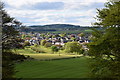
Image Map
Images are licensed for reuse under creativecommons.org/licenses/by-sa/2.0
Notes
- Clicking on the map will re-center to the selected point.
- The higher the marker number, the further away the image location is from the centre of the postcode.
Image Listing (41 Images Found)
Images are licensed for reuse under creativecommons.org/licenses/by-sa/2.0
Image
Details
Distance
3
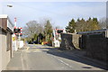
Level crossing (automatic half barriers)
The Aberdeen-Inverurie single line crosses the B977 to Hatton
Image: © Bill Harrison
Taken: 1 Apr 2010
0.12 miles
4
School Road, Kintore
Once the main Aberdeen to Inverness road, and lined with granite cottages but now peaceful on a Sunday morning.
Image: © Bill Harrison
Taken: 19 Feb 2017
0.12 miles
5
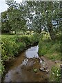
Tuach Burn
Looking east from the little bridge that leads to the path up to Tuach Hill.
Image: © Angela Jones
Taken: 2 Aug 2024
0.13 miles
6
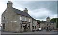
Kintore Arms Inn and Town House
Traditional stone buildings in the centre of Kintore, now a dormitory town for Aberdeen. Through traffic has been much reduced since the by-pass was built on the A96.
Image: © Colin Smith
Taken: 11 Jul 2008
0.13 miles
7
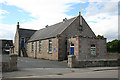
Village Hall
The hall was originally built as a drill hall in 1894.
Image: © Anne Burgess
Taken: 30 Jul 2014
0.13 miles
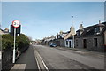
8
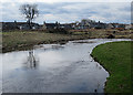
River Don at Kintore
It's not obvious from this view, but the village is cut off from the river bank by the railway which runs along behind the houses seen here.
Image: © Anne Burgess
Taken: 9 Apr 2018
0.13 miles
9
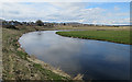
River Don
The River Don meanders through its floodplain. This is a meander close to the village of Kintore, but separated from the village by the railway. The map names this reach of the river as Burnmouth Pot.
Image: © Anne Burgess
Taken: 9 Apr 2018
0.14 miles
10
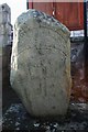
Kintore Churchyard Pictish Stone
A seventh century stone, set in a corner of the churchyard, it has been reset from an unknown position nearby. See http://www.aberdeenshire.gov.uk/archaeology/sites/pictish/kintore.asp
Image: © Andrew Wood
Taken: 8 Oct 2008
0.15 miles