IMAGES TAKEN NEAR TO
AB5 0HT
Introduction
This page details the photographs taken nearby to AB5 0HT by members of the Geograph project.
The Geograph project started in 2005 with the aim of publishing, organising and preserving representative images for every square kilometre of Great Britain, Ireland and the Isle of Man.

There are currently over 7.5m images from over14,400 individuals and you can help contribute to the project by visiting https://www.geograph.org.uk
Image Map
Images are licensed for reuse under creativecommons.org/licenses/by-sa/2.0
Notes
- Clicking on the map will re-center to the selected point.
- The higher the marker number, the further away the image location is from the centre of the postcode.
Image Listing (3 Images Found)
Images are licensed for reuse under creativecommons.org/licenses/by-sa/2.0
Image
Details
Distance
1
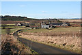
Mill of Bourtie
Like many others around here, the redundant farm steading at Mill of Bourtie has been converted to housing, at a convenient commuting distance from Aberdeen.
Image: © Anne Burgess
Taken: 18 Feb 2016
0.05 miles
3
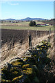
Mossy Dyke
From the roadside here there is a wide view towards Bennachie. I think the buildings in the middle distance are Lethenty Kennels.
Image: © Anne Burgess
Taken: 18 Feb 2016
0.13 miles