IMAGES TAKEN NEAR TO
AB4 6JN
Introduction
This page details the photographs taken nearby to AB4 6JN by members of the Geograph project.
The Geograph project started in 2005 with the aim of publishing, organising and preserving representative images for every square kilometre of Great Britain, Ireland and the Isle of Man.

There are currently over 7.5m images from over14,400 individuals and you can help contribute to the project by visiting https://www.geograph.org.uk
Image Map
Images are licensed for reuse under creativecommons.org/licenses/by-sa/2.0
Notes
- Clicking on the map will re-center to the selected point.
- The higher the marker number, the further away the image location is from the centre of the postcode.
Image Listing (235 Images Found)
Images are licensed for reuse under creativecommons.org/licenses/by-sa/2.0
Image
Details
Distance
1
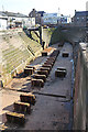
Graving Dock
The dry dock was built in 1853-1855 to accommodate Greenland whaling vessels. It was designed by Thomas Stevenson, and is 148 feet long and 54 feet wide. Stevenson wanted to use steam-drive pumps to empty it, but the harbour trustees were suspicious of new technology, and the cheaper option of horse-operated pumps was adopted. The cost was £6000, and it was financed by a levy of 6s 6d per ton of oil landed in the port.
Image: © Anne Burgess
Taken: 26 Aug 2019
0.01 miles
2
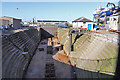
Dry Dock
The dry dock was built in 1853-1855 to accommodate Greenland whaling vessels. It was designed by Thomas Stevenson, and is 148 feet long and 54 feet wide. Stevenson wanted to use steam-drive pumps to empty it, but the harbour trustees were suspicious of new technology, and the cheaper option of horse-operated pumps was adopted. The cost was £6000, and it was financed by a levy of 6s 6d per ton of oil landed in the port.
Image: © Anne Burgess
Taken: 26 Aug 2019
0.01 miles
3
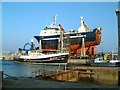
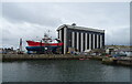
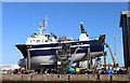
Peterhead ship-lift
Modern hydraulic lift capable of raising large fishing vessels onto land and moving them into a repair shed (just visible at extreme right).
In the foreground is the 1885 dry dock originally built to repair the wooden vessels of the Greenland whaling fleet based in Peterhead.
The trawlers are PD197 Atlantic Challenge, and PD230 Starlight Days.
Image: © Martyn Gorman
Taken: 21 Mar 2003
0.01 miles
4
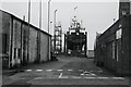
Farmer's Lane, Peterhead
FR273 Ocean Reaper IV
Image: © Richard Webb
Taken: 1 Aug 2020
0.02 miles
5
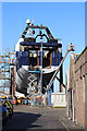
On the Blocks
'Atlantic Challenge' PD 197 on the blocks in the shipyard at Peterhead Harbour. She seems to be the latest in a series of vessels bearing the number PD 197. Coincidentally, see Image]! The lift can hoist ships of up to 2000 tonnes and move them into the vast shed alongside to be worked on.
Image: © Anne Burgess
Taken: 26 Aug 2019
0.03 miles
6
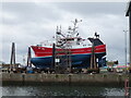
Fishing boat repairs, Scott's Pier, Peterhead
WY 261 Our Lass III.
Image: © JThomas
Taken: 25 Aug 2020
0.03 miles
7
Boat repair shed, Scott's Pier, Peterhead
WY 261 Our Lass III out front.
Image: © JThomas
Taken: 25 Aug 2020
0.03 miles
8
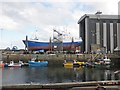
Ship repair yard, Scott's Pier, Peterhead
Image: © Roger Cornfoot
Taken: 31 May 2015
0.03 miles
9
On the Blocks
'Atlantic Challenge' PD 197 on the blocks in the shipyard at Peterhead Harbour. She seems to be the latest in a series of vessels bearing the number PD 197. Coincidentally, see Image]! The lift can hoist ships of up to 2000 tonnes and move them into the vast shed alongside to be worked on.
Image: © Anne Burgess
Taken: 26 Aug 2019
0.03 miles
10
Peterhead Harbour
The outhouse of the derelict cottage at Image provides a fine view of Peterhead harbour.
The prominent structure at the centre of the picture is the Ship Lift, seen in operation at Image
Image: © Iain Smith
Taken: 23 Feb 2010
0.04 miles