IMAGES TAKEN NEAR TO
The Green, BANFF, AB45 3YY
Introduction
This page details the photographs taken nearby to The Green, AB45 3YY by members of the Geograph project.
The Geograph project started in 2005 with the aim of publishing, organising and preserving representative images for every square kilometre of Great Britain, Ireland and the Isle of Man.

There are currently over 7.5m images from over14,400 individuals and you can help contribute to the project by visiting https://www.geograph.org.uk
Image Map
Images are licensed for reuse under creativecommons.org/licenses/by-sa/2.0
Notes
- Clicking on the map will re-center to the selected point.
- The higher the marker number, the further away the image location is from the centre of the postcode.
Image Listing (77 Images Found)
Images are licensed for reuse under creativecommons.org/licenses/by-sa/2.0
Image
Details
Distance
1
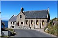
Gardenstown New Church
Not so new as its name implies it was founded in 1899 as a United Presbyterian Church becoming a Church of Scotland kirk in 1932.
Image: © Andrew Wood
Taken: 21 Jul 2020
0.02 miles
2
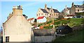
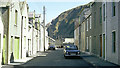
Gardenstown
The road out of Gardenstown winds steeply up the hill in a series of hairpin bends, one of which is dominated by the Church of Scotland kirk, seen here on the skyline.
Image: © Anne Burgess
Taken: 24 Oct 2007
0.03 miles
3
Gardenstown Church of Scotland
There are several different denominations of kirk in Gardenstown. The Church of Scotland one stands halfway up the hill, and is seen here from the next hairpin bend up.
Image: © Anne Burgess
Taken: 24 Oct 2007
0.04 miles
5
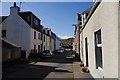
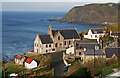
Gardenstown
A residential street leading towards the harbour.
Image: © Richard Webb
Taken: 15 Apr 2015
0.07 miles
6
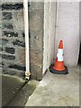
Section of 139 Church Road, Gardenstown showing OS Cut Mark
Section of 139 Church Road, Gardenstown showing clear OS Cut Mark
Image: © thejackrustles
Taken: 19 Jul 2015
0.07 miles
7
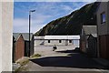
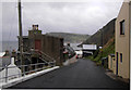
New Ground, Gardenstown
The north end of the village with several sheds and buildings associated with fishing.
Image: © Richard Webb
Taken: 15 Apr 2015
0.07 miles
8
Houses in New Ground
The photograph shows houses in New Ground, Gardenstown.
The harbour is a few metres behind the viewpoint.
For another photograph (1976) of housing in Gardentown, click here: http://www.geograph.org.uk/photo/2252714 .
- - -
See also this web site from Undiscovered Scotland: http://www.undiscoveredscotland.co.uk/gardenstown/gardenstown/
- - -
Note: The Date Taken is the processing date printed on the slide and therefore the photograph could have been taken several weeks earlier.
Image: © Alan Walker
Taken: Unknown
0.07 miles
9
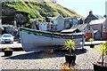
High and Dry
An old boat in gravel near the New Ground in Gardenstown.
Image: © Andrew Wood
Taken: 21 Jul 2020
0.07 miles
10
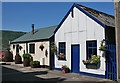
Corrugated Cottage
This is the other end of Image], cheerfully decorated with window boxes and hanging baskets.
Image: © Anne Burgess
Taken: 25 Jul 2014
0.08 miles