IMAGES TAKEN NEAR TO
Gardenstown, BANFF, AB45 3YJ
Introduction
This page details the photographs taken nearby to AB45 3YJ by members of the Geograph project.
The Geograph project started in 2005 with the aim of publishing, organising and preserving representative images for every square kilometre of Great Britain, Ireland and the Isle of Man.

There are currently over 7.5m images from over14,400 individuals and you can help contribute to the project by visiting https://www.geograph.org.uk
Image Map
Images are licensed for reuse under creativecommons.org/licenses/by-sa/2.0
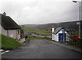
Notes
- Clicking on the map will re-center to the selected point.
- The higher the marker number, the further away the image location is from the centre of the postcode.
Image Listing (44 Images Found)
Images are licensed for reuse under creativecommons.org/licenses/by-sa/2.0
Image
Details
Distance
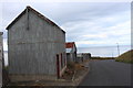
2
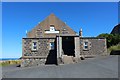
Gamrie Dreel Hall
Otherwise known as Gardenstown Public Hall it is still remembered as an old drill hall.
Image: © Andrew Wood
Taken: 21 Jul 2020
0.11 miles
3
Gardenstown Public Hall
The noticeboard on the left describes it as the Dreel Hall. It was indeed originally a drill hall, built for the 1st Banffshire Garrison Artillery Volunteers who became Banffshire Battery Royal Field Artillery after the Haldane Reforms in 1908.
Image: © Anne Burgess
Taken: 25 Jul 2014
0.11 miles
4
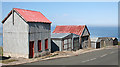
Red Sheds
Well, red-roofed ones among others. Sited precariously on the side of the High Street as it snakes steeply down to the shore.
Image: © Anne Burgess
Taken: 25 Jul 2014
0.13 miles
5
Gamrie Brae Sheds
An assortment of sheds lining Gamrie Brae by the Dreel Hall with a view to Gamrie Bay beyond.
Image: © Andrew Wood
Taken: 21 Jul 2020
0.13 miles
6
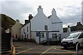
Garden Arms
The Garden Arms Hotel tucked against the sandstome cliffs.
Image: © Andrew Wood
Taken: 21 Jul 2020
0.18 miles
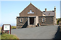
7
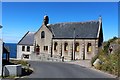
Gardenstown New Church
Not so new as its name implies it was founded in 1899 as a United Presbyterian Church becoming a Church of Scotland kirk in 1932.
Image: © Andrew Wood
Taken: 21 Jul 2020
0.19 miles
8
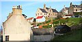
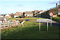
Gardenstown
The road out of Gardenstown winds steeply up the hill in a series of hairpin bends, one of which is dominated by the Church of Scotland kirk, seen here on the skyline.
Image: © Anne Burgess
Taken: 24 Oct 2007
0.19 miles
10
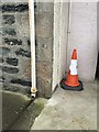
Section of 139 Church Road, Gardenstown showing OS Cut Mark
Section of 139 Church Road, Gardenstown showing clear OS Cut Mark
Image: © thejackrustles
Taken: 19 Jul 2015
0.20 miles