IMAGES TAKEN NEAR TO
Alvah, BANFF, AB45 3XB
Introduction
This page details the photographs taken nearby to AB45 3XB by members of the Geograph project.
The Geograph project started in 2005 with the aim of publishing, organising and preserving representative images for every square kilometre of Great Britain, Ireland and the Isle of Man.

There are currently over 7.5m images from over14,400 individuals and you can help contribute to the project by visiting https://www.geograph.org.uk
Image Map
Images are licensed for reuse under creativecommons.org/licenses/by-sa/2.0
Notes
- Clicking on the map will re-center to the selected point.
- The higher the marker number, the further away the image location is from the centre of the postcode.
Image Listing (1 Images Found)
Images are licensed for reuse under creativecommons.org/licenses/by-sa/2.0
Image
Details
Distance
1
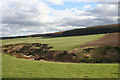
Rosy Burn
The rosy Burn has cut down into the glacial deposits that mantle the land her, producing a sharp contrast between the cultivated fields and the rough vegetation of the den. Brownside Wood covers the top of the slope.
Image: © Anne Burgess
Taken: 8 Apr 2014
0.14 miles