IMAGES TAKEN NEAR TO
Alvah, BANFF, AB45 3UT
Introduction
This page details the photographs taken nearby to AB45 3UT by members of the Geograph project.
The Geograph project started in 2005 with the aim of publishing, organising and preserving representative images for every square kilometre of Great Britain, Ireland and the Isle of Man.

There are currently over 7.5m images from over14,400 individuals and you can help contribute to the project by visiting https://www.geograph.org.uk
Image Map
Images are licensed for reuse under creativecommons.org/licenses/by-sa/2.0
Notes
- Clicking on the map will re-center to the selected point.
- The higher the marker number, the further away the image location is from the centre of the postcode.
Image Listing (19 Images Found)
Images are licensed for reuse under creativecommons.org/licenses/by-sa/2.0
Image
Details
Distance
1
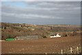
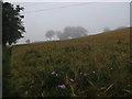
Mill of Alvah
Fields ready for spring planting. Beyond the farm there is a glimpse of the River Deveron.
Image: © Anne Burgess
Taken: 23 Mar 2007
0.00 miles
2
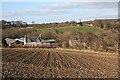
Mill of Alvah
The house and steading at Mill of Alvah, with new houses on the brae above.
Image: © Anne Burgess
Taken: 23 Mar 2007
0.02 miles
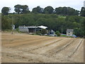
4
Alvah
Mixed arable and pasture land at Alvah.
Image: © Anne Burgess
Taken: 23 Mar 2007
0.10 miles
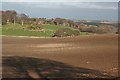
5
A field north of Mill of Alvah
We didn't find a way to the famous Bridge of Alvah here
Image: © Ulrich Hartmann
Taken: 21 Aug 2007
0.17 miles
6
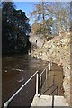
The Height of the Spate
This is the platform from which Image] descends to river level. I estimate that the railings here are a good five metres above the present, still high, water level, and they are festooned with debris which was presumably washed down by the recent spate.
Image: © Anne Burgess
Taken: 19 Mar 2010
0.18 miles
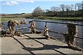
7
Riverside Walkway
This is another part of the walkway in Image The level of the river is evidently still above normal, because part of it is still under water.
Image: © Anne Burgess
Taken: 19 Mar 2010
0.20 miles
8
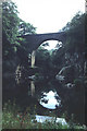
Bridge of Alvah
Spectacular stone bridge spanning a gorge of the River Deveron.
Image: © Peter Ward
Taken: 17 Aug 1996
0.21 miles
9
Banff, Bridge of Alvah
A wider angle showing the location of the cut mark on the western parapet of this impressive bridge.
Image: © Mel Towler
Taken: 27 Jun 2021
0.21 miles
10
Banff, Bridge of Alvah
This is the western parapet of the bridge, with a deep cut benchmark directly above the running water many feet below. The cut mark is about 3 foot above the level of the bridge, however the bridge is many feet above the steam.
Image: © Mel Towler
Taken: 27 Jun 2021
0.21 miles