IMAGES TAKEN NEAR TO
Alvah, BANFF, AB45 3DJ
Introduction
This page details the photographs taken nearby to AB45 3DJ by members of the Geograph project.
The Geograph project started in 2005 with the aim of publishing, organising and preserving representative images for every square kilometre of Great Britain, Ireland and the Isle of Man.

There are currently over 7.5m images from over14,400 individuals and you can help contribute to the project by visiting https://www.geograph.org.uk
Image Map
Images are licensed for reuse under creativecommons.org/licenses/by-sa/2.0
Notes
- Clicking on the map will re-center to the selected point.
- The higher the marker number, the further away the image location is from the centre of the postcode.
Image Listing (4 Images Found)
Images are licensed for reuse under creativecommons.org/licenses/by-sa/2.0
Image
Details
Distance
1
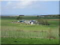
Coldhome Farm
Looking westwards down from the roadside towards Coldhome.
Image: © Scott Cormie
Taken: 7 May 2022
0.02 miles
2
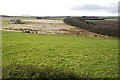
Muiryhill from Hill of Ryland
There is boggy ground at the foot of the slope here. This is the source of the Burn of Muiryhill. The house at left, Coldhome, is in the next square.
Image: © Anne Burgess
Taken: 27 Feb 2008
0.16 miles
3
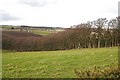
Shelter Belt
The shelter belt runs down from the summit of the Hill of Ryland to the valley bottom. The farms visible over the top of the shelter belt are Dens of Muiryhill on the left and Sketraw to the right.
Image: © Anne Burgess
Taken: 27 Feb 2008
0.16 miles
4
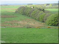
Rough ground from the Hill of Ryland
Looking down from the Hill of Ryland to rough pastureland.
Image: © Scott Cormie
Taken: 7 May 2022
0.22 miles