IMAGES TAKEN NEAR TO
BANFF, AB45 3AR
Introduction
This page details the photographs taken nearby to AB45 3AR by members of the Geograph project.
The Geograph project started in 2005 with the aim of publishing, organising and preserving representative images for every square kilometre of Great Britain, Ireland and the Isle of Man.

There are currently over 7.5m images from over14,400 individuals and you can help contribute to the project by visiting https://www.geograph.org.uk
Image Map
Images are licensed for reuse under creativecommons.org/licenses/by-sa/2.0
Notes
- Clicking on the map will re-center to the selected point.
- The higher the marker number, the further away the image location is from the centre of the postcode.
Image Listing (5 Images Found)
Images are licensed for reuse under creativecommons.org/licenses/by-sa/2.0
Image
Details
Distance
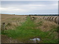
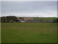
3
Looking towards Little Blairshinnoch
Little Blairshinnoch is just inside the next square here; the foreground fields are all in the square. The trees line the north end of the road through Backhill of Culbirnie, and the ever-present Boyndie wind farm is in the distance.
Image: © Anne Burgess
Taken: 17 Feb 2011
0.15 miles
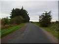
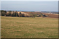
4
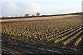
A Park o' Neeps
In the speech of north-east Scotland, a 'park' is a field and 'neeps' are turnips or swedes. These serried ranks of root vegetables are on the slopes of the Hill of Culbirnie. The trees on the skyline mark the location of Backhill of Culbirnie.
Image: © Anne Burgess
Taken: 17 Feb 2011
0.15 miles