IMAGES TAKEN NEAR TO
Portsoy, BANFF, AB45 2YD
Introduction
This page details the photographs taken nearby to AB45 2YD by members of the Geograph project.
The Geograph project started in 2005 with the aim of publishing, organising and preserving representative images for every square kilometre of Great Britain, Ireland and the Isle of Man.

There are currently over 7.5m images from over14,400 individuals and you can help contribute to the project by visiting https://www.geograph.org.uk
Image Map
Images are licensed for reuse under creativecommons.org/licenses/by-sa/2.0
Notes
- Clicking on the map will re-center to the selected point.
- The higher the marker number, the further away the image location is from the centre of the postcode.
Image Listing (10 Images Found)
Images are licensed for reuse under creativecommons.org/licenses/by-sa/2.0
Image
Details
Distance
1
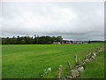
Fields and houses near Damheads
South of Portsoy.
Image: © David Purchase
Taken: 11 Jun 2019
0.02 miles
2
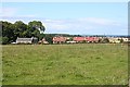
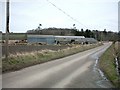
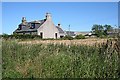
Cottages near Damheads
This row of cottages is marked but not named on the maps. They look as if they date from the mid-20th century. In the distance is the burgh of Portsoy.
Image: © Anne Burgess
Taken: 5 Aug 2010
0.02 miles
3
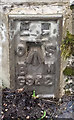
Flush Bracket OSBM G942: Damheads Bridge
Ordnance Survey Flush Bracket OSBM G942: Damheads Bridge
Image: © thejackrustles
Taken: 22 Feb 2015
0.08 miles
4
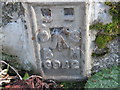
Ordnance Survey Flush Bracket G942
This can be found on Damheads Bridge.
For more detail see : http://www.bench-marks.org.uk/bm16957
Image: © Peter Wood
Taken: 5 Oct 2012
0.08 miles
5
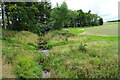
Burn of Durn
Looking upstream from the road bridge at Damheads.
Image: © Anne Burgess
Taken: 26 Aug 2022
0.09 miles
6
Damheads near Portsoy
Farm buildings at Damheads.
Image: © Christopher Gillan
Taken: 12 Apr 2006
0.13 miles
7
Knockdurn
The cottages to the right of the farm are by the back road to Fordyce via Damheads.
Image: © Anne Burgess
Taken: 26 Mar 2007
0.17 miles
8
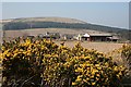
Knockdurn
A closer view of the buildings at Knockdurn. The farm shares its name with Durn Hill, which is in the next square; 'knock' is from Gaelic and means 'hill'.
Image: © Anne Burgess
Taken: 26 Mar 2007
0.17 miles
9
Knockdurn
The traditional farm cottage at Knockdurn stands close to the B9022, from which this view was taken.
Image: © Anne Burgess
Taken: 5 Aug 2010
0.18 miles
10
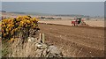
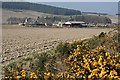
Knockdurn
I think this machine is for sowing seeds. The farm just visible to the right of the whin bush is Mill of Durn, and the outskirts of Portsoy are on the skyline at right.
Image: © Anne Burgess
Taken: 26 Mar 2007
0.22 miles