IMAGES TAKEN NEAR TO
Fordyce, BANFF, AB45 2UR
Introduction
This page details the photographs taken nearby to AB45 2UR by members of the Geograph project.
The Geograph project started in 2005 with the aim of publishing, organising and preserving representative images for every square kilometre of Great Britain, Ireland and the Isle of Man.

There are currently over 7.5m images from over14,400 individuals and you can help contribute to the project by visiting https://www.geograph.org.uk
Image Map
Images are licensed for reuse under creativecommons.org/licenses/by-sa/2.0
Notes
- Clicking on the map will re-center to the selected point.
- The higher the marker number, the further away the image location is from the centre of the postcode.
Image Listing (5 Images Found)
Images are licensed for reuse under creativecommons.org/licenses/by-sa/2.0
Image
Details
Distance
1
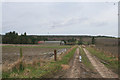
Breach
Breach Farm is right on the gridline, but all the foreground is in square.
Image: © Anne Burgess
Taken: 23 Feb 2010
0.03 miles
2
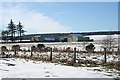
Breach
Breach is the farm towards the right-hand side of this view. The map I was using showed the access from the far side, but there is now a new road from this side. In the background is Fordyce Hill. A solitary whin bush seems to have escaped the fate of its neighbours, all of which have been removed.
Image: © Anne Burgess
Taken: 20 Jan 2011
0.07 miles
3
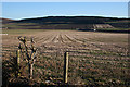
Cairnton and Breach
The cottage by the road on the right is unnamed on the maps. Breach is immediately to its left, and Cairnton, in the next square, is in the distance on the left.
Image: © Anne Burgess
Taken: 23 Feb 2010
0.14 miles
4
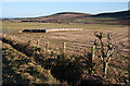
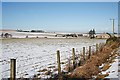
Near Fordyce
The bales in the foreground are beside a new access to Breach. In the distance is Durn Hill, with the village of Fordyce at its foot and Fordyce Hill to the right. I wonder how that one solitary whin bush escaped destruction with its fellows?
Image: © Anne Burgess
Taken: 20 Jan 2011
0.22 miles