IMAGES TAKEN NEAR TO
Portsoy, BANFF, AB45 2TQ
Introduction
This page details the photographs taken nearby to AB45 2TQ by members of the Geograph project.
The Geograph project started in 2005 with the aim of publishing, organising and preserving representative images for every square kilometre of Great Britain, Ireland and the Isle of Man.

There are currently over 7.5m images from over14,400 individuals and you can help contribute to the project by visiting https://www.geograph.org.uk
Image Map
Images are licensed for reuse under creativecommons.org/licenses/by-sa/2.0
Notes
- Clicking on the map will re-center to the selected point.
- The higher the marker number, the further away the image location is from the centre of the postcode.
Image Listing (13 Images Found)
Images are licensed for reuse under creativecommons.org/licenses/by-sa/2.0
Image
Details
Distance
1
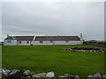
Westerwards Croft
Holiday cottage on cliff tops, near Portsoy.
Image: © Peter Barr
Taken: 13 Sep 2011
0.02 miles
2
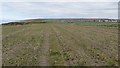
Stubble, Portsoy
A field which is yet to be ploughed. It is between a road and the coast.
Image: © Richard Webb
Taken: 16 Apr 2015
0.06 miles
4
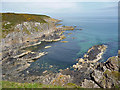
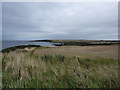
Coast near Portsoy
Looking to seaward from the cliff top west of Portsoy.
Image: © Anne Burgess
Taken: 31 May 2014
0.15 miles
5
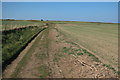
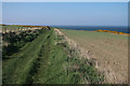
On coastal path, near Portsoy
Looking eastwards over harvested fields.
Image: © Peter Barr
Taken: 13 Sep 2011
0.16 miles
6
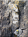
Metamorphosed Sedimentary Rocks
The vertical rock with the white lichen on it is a metamorphosed sandstone. On either side of it are layers of metamorphosed mudstone. The mudstone contains softer minerals than the sandstone, so they are deformed by the pressure of metamorphosis to show a fabric that looks like parallel laminae, while the sandstone looks unaffected.
Image: © Anne Burgess
Taken: 31 May 2014
0.18 miles
8
Arnbath Psammite
Psammite is a term to describe metamorphosed sandstone. This started out as slightly impure sandstone, and has been tilted almost vertically to form sharp layers of quartz.
Image: © Anne Burgess
Taken: 31 May 2014
0.20 miles
9
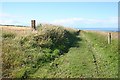
Coastal Path
The path follows farm roads to here, and this section is obviously being well maintained, the grass being regularly mown.
Image: © Anne Burgess
Taken: 5 Aug 2010
0.21 miles
10
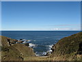
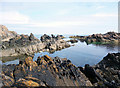
Inlet near Redhythe Point
Another inlet on this rocky headland near Portsoy. A very peaceful sea for early March!
Image: © Christopher Gillan
Taken: 2 Mar 2007
0.21 miles