IMAGES TAKEN NEAR TO
Portsoy, BANFF, AB45 2TN
Introduction
This page details the photographs taken nearby to AB45 2TN by members of the Geograph project.
The Geograph project started in 2005 with the aim of publishing, organising and preserving representative images for every square kilometre of Great Britain, Ireland and the Isle of Man.

There are currently over 7.5m images from over14,400 individuals and you can help contribute to the project by visiting https://www.geograph.org.uk
Image Map
Images are licensed for reuse under creativecommons.org/licenses/by-sa/2.0
Notes
- Clicking on the map will re-center to the selected point.
- The higher the marker number, the further away the image location is from the centre of the postcode.
Image Listing (4 Images Found)
Images are licensed for reuse under creativecommons.org/licenses/by-sa/2.0
Image
Details
Distance
1
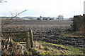
Kindrought
The farm buildings at Kindrought, seen across the recently ploughed fields from the minor road.
Image: © Anne Burgess
Taken: 17 Feb 2011
0.10 miles
2
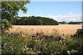
Near Kindrought
A field of barley, almost ready for harvesting, beside the unclassified road north of Kindrought.
Image: © Anne Burgess
Taken: 5 Aug 2010
0.22 miles
3
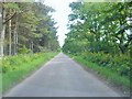
Minor road off A98
Near Kindrought; heading towards Scotsmill/Boyne Castle. A longish straight stretch of this minor road runs between two 'shelter belts' of trees.
Image: © Stanley Howe
Taken: 23 Jul 2015
0.23 miles
4
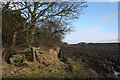
Near Kindrought
The margin of the fields alongside the minor road is lined with mature trees. The farm on the skyline is Brangan, in the next square, and at extreme right is one of the wind turbines on the former airfield at Boyndie.
Image: © Anne Burgess
Taken: 17 Feb 2011
0.24 miles