IMAGES TAKEN NEAR TO
Boyndie, BANFF, AB45 2LJ
Introduction
This page details the photographs taken nearby to AB45 2LJ by members of the Geograph project.
The Geograph project started in 2005 with the aim of publishing, organising and preserving representative images for every square kilometre of Great Britain, Ireland and the Isle of Man.

There are currently over 7.5m images from over14,400 individuals and you can help contribute to the project by visiting https://www.geograph.org.uk
Image Map
Images are licensed for reuse under creativecommons.org/licenses/by-sa/2.0
Notes
- Clicking on the map will re-center to the selected point.
- The higher the marker number, the further away the image location is from the centre of the postcode.
Image Listing (5 Images Found)
Images are licensed for reuse under creativecommons.org/licenses/by-sa/2.0
Image
Details
Distance
1
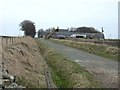
Wester Whyntie Farm near Portsoy
The farm is situated in very close proximity to a wind turbine site which is under construction.
Image: © Christopher Gillan
Taken: 12 Apr 2006
0.05 miles
2
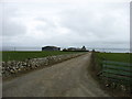
Wester Whyntie
A substantial farm, its stubble fields still awaiting spring ploughing.
Image: © Anne Burgess
Taken: 24 Feb 2011
0.06 miles
3
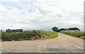
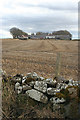
Access road to Wester Whyntie from B9139
Wester Whyntie is on the right; the other building named on the sign (Whyntie Lodge) is not apparent on current OS maps. This whole area was once a wartime airfield.
Image: © Stanley Howe
Taken: 23 Jul 2015
0.12 miles
5
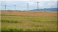
Farmland, Boyndie
Ripening barley within earshot of a small wind farm.
Image: © Richard Webb
Taken: 5 Aug 2011
0.21 miles